IMAGES TAKEN NEAR TO
Belan, WELSHPOOL, SY21 8SJ
Introduction
This page details the photographs taken nearby to SY21 8SJ by members of the Geograph project.
The Geograph project started in 2005 with the aim of publishing, organising and preserving representative images for every square kilometre of Great Britain, Ireland and the Isle of Man.

There are currently over 7.5m images from over14,400 individuals and you can help contribute to the project by visiting https://www.geograph.org.uk
Image Map
Images are licensed for reuse under creativecommons.org/licenses/by-sa/2.0
Notes
- Clicking on the map will re-center to the selected point.
- The higher the marker number, the further away the image location is from the centre of the postcode.
Image Listing (3 Images Found)
Images are licensed for reuse under creativecommons.org/licenses/by-sa/2.0
Image
Details
Distance
1
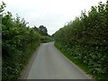
High hedges
Lining the sides of this minor road.
Image: © James Allan
Taken: 1 Sep 2007
0.14 miles
2
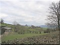
Verniew Farm
This shows typical Border farmland with the Bridden Hills beyond
Image: © George Wolfe
Taken: 16 Apr 2006
0.22 miles
3
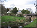
Belan Church beside the Montgomery Canal
This chapel is still in use and services are held monthly. The hall is also used by various clubs/societies. There is residential accommodation adjoining the chapel.
Image: © George Wolfe
Taken: 16 Apr 2006
0.24 miles