IMAGES TAKEN NEAR TO
Fron, WELSHPOOL, SY21 8RX
Introduction
This page details the photographs taken nearby to SY21 8RX by members of the Geograph project.
The Geograph project started in 2005 with the aim of publishing, organising and preserving representative images for every square kilometre of Great Britain, Ireland and the Isle of Man.

There are currently over 7.5m images from over14,400 individuals and you can help contribute to the project by visiting https://www.geograph.org.uk
Image Map
Images are licensed for reuse under creativecommons.org/licenses/by-sa/2.0
Notes
- Clicking on the map will re-center to the selected point.
- The higher the marker number, the further away the image location is from the centre of the postcode.
Image Listing (26 Images Found)
Images are licensed for reuse under creativecommons.org/licenses/by-sa/2.0
Image
Details
Distance
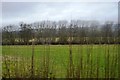
4
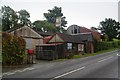
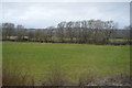
Farm buildings in Cilcewydd
Cilcewydd is sparser than it appears on the map, and this is the southern edge.
Image: © Bill Boaden
Taken: 25 Sep 2012
0.07 miles
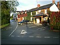
6
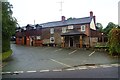
The Square & Compass, Cilcewydd
I didn't have a chance to visit, but it appears to have retained the old facade while new accommodation blocks have been added behind.
Image: © Bill Boaden
Taken: 25 Sep 2012
0.09 miles
8
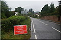
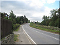
Road through Cilcewydd
There is not a lot to see of the village, with the road junction and mill at the bottom being the most noticeable parts. The road is closed because of floods beyond the village after it has crossed the Severn.
Image: © Bill Boaden
Taken: 25 Sep 2012
0.12 miles
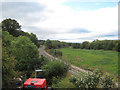
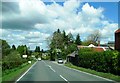
10
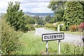
Looking to Cilcewydd from Fron Bank turning.
Image: © Don Cawthra
Taken: 1 Jul 2007
0.14 miles