IMAGES TAKEN NEAR TO
Buttington, WELSHPOOL, SY21 8HB
Introduction
This page details the photographs taken nearby to SY21 8HB by members of the Geograph project.
The Geograph project started in 2005 with the aim of publishing, organising and preserving representative images for every square kilometre of Great Britain, Ireland and the Isle of Man.

There are currently over 7.5m images from over14,400 individuals and you can help contribute to the project by visiting https://www.geograph.org.uk
Image Map
Images are licensed for reuse under creativecommons.org/licenses/by-sa/2.0
Notes
- Clicking on the map will re-center to the selected point.
- The higher the marker number, the further away the image location is from the centre of the postcode.
Image Listing (6 Images Found)
Images are licensed for reuse under creativecommons.org/licenses/by-sa/2.0
Image
Details
Distance
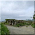
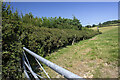
2
On The Horizon
View of Welshpool from minor road beneath Oak Plantation.
Image: © J Scott
Taken: 24 Jan 2008
0.13 miles
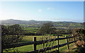
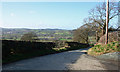
3
Steep hill to Buttington (2)
Marked on OS map with two arrows (greater than 20%). View beyond to Welshpool and the valley
Image: © David Smith
Taken: 24 Apr 2015
0.14 miles
4
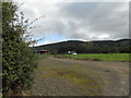
Farm access above Buttington
The track ahead leads down to Buttington, but traffic has to follow a longer route via the A458
Image: © David Smith
Taken: 24 Apr 2015
0.15 miles
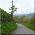
6
The Road Down To Buttington
Road going downhill towards Buttington at junction with farm track to Cletterwood.
Image: © J Scott
Taken: 24 Jan 2008
0.22 miles