IMAGES TAKEN NEAR TO
Powells Lane, WELSHPOOL, SY21 7JY
Introduction
This page details the photographs taken nearby to Powells Lane, SY21 7JY by members of the Geograph project.
The Geograph project started in 2005 with the aim of publishing, organising and preserving representative images for every square kilometre of Great Britain, Ireland and the Isle of Man.

There are currently over 7.5m images from over14,400 individuals and you can help contribute to the project by visiting https://www.geograph.org.uk
Image Map
Images are licensed for reuse under creativecommons.org/licenses/by-sa/2.0
Notes
- Clicking on the map will re-center to the selected point.
- The higher the marker number, the further away the image location is from the centre of the postcode.
Image Listing (203 Images Found)
Images are licensed for reuse under creativecommons.org/licenses/by-sa/2.0
Image
Details
Distance
1
Former Primitive Methodist Chapel, Brook Street
Built in 1870, this has now been converted into flats.
Image: © Eirian Evans
Taken: 3 Aug 2021
0.04 miles
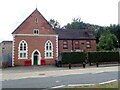
2
Welsh Independent Chapel, Welshpool
Just off the High Street. Established in 1876 and believed to be still offering services (in 2020). Coflein: https://www.coflein.gov.uk/en/site/11480/details/welsh-independent-chapel-powells-lane-welshpool
Image: © John Lucas
Taken: 31 Jul 2006
0.05 miles
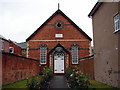
3
Welsh Independent Chapel, Welshpool
This is set back from the high street so that it is easy to miss.
Image: © Bill Boaden
Taken: 25 Feb 2011
0.06 miles
4
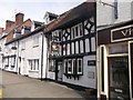
The Mermaid in High Street
Difficult shot to take as there is a large bus shelter directly in front of the pub
Image: © John Firth
Taken: 27 Jun 2013
0.06 miles
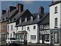
5
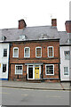
21 and 22 High Street, Welshpool
Along with 20, 21 and 22 are a block of 3 Grade II Listed houses built as a single development by the Powis Estate about 1740. 21 & 22 incorporated earlier fabric. A desk-top study in 2002 by Clwyd Powys Archaeological Trust demonstrated that the High Street frontage was occupied by at least 1629. An excavation demonstrated evidence, with a small assemblage of medieval artefacts, that the plot may have been occupied during the 14th or 15th century, presumably forming part of a rear yard to properties fronting onto High Street. No.21, 5 floors from cellar to attic is a 1,644 sq ft 3 bedroom house. I assume 22 is a similar reflected plan.
Image: © Jo and Steve Turner
Taken: 20 Jul 2022
0.06 miles
6
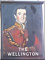
Sign for the Wellington, Welshpool
Arthur Wellesley, 1st Duke of Wellington (1769-1852) was a British national hero after his defeat of Napoleon 1 at Waterloo, 1815. He had earlier had a distinguished military career in India and Spain. Between 1828-30 he was prime minister, later he was foreign secretary 1834-35. His popularity may be judged by the fact that he is mentioned on more pub signs than anyone except Lord Nelson.
Image: © Maigheach-gheal
Taken: 7 Sep 2007
0.07 miles
7
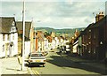
High Street (A458), Welshpool in 1985
The tower on the left is that of St Mary's church. The steeple on the right is that of the Methodist church.
Image: © John Baker
Taken: 15 Sep 1985
0.07 miles
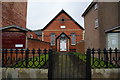
8
Welshpool, Welsh Chapel
Welsh Chapel (Eglwys yr Annibynwyr) beyond wall which carries an Ordnance Survey cut mark benchmark on the middle stone block. The mark was verified and levelled at 88.789m above Newlyn datum in 1973. More information on this and other benchmarks can be found on the Bench Mark Database at http://www.bench-marks.org.uk/bm34588.
Image: © Roger Templeman
Taken: 5 Jun 2010
0.07 miles
9
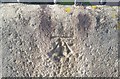
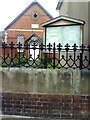
Ordnance Survey Cut Mark
This OS cut mark can be found on the wall of the Welsh Chapel. It marks a point 88.789m above mean sea level.
Image: © Adrian Dust
Taken: 11 Sep 2018
0.07 miles
10
Stryd Fawr y Trallwng / Welshpool High Street
Image: © Ceri Thomas
Taken: 27 Mar 2022
0.07 miles