IMAGES TAKEN NEAR TO
Dolanog, WELSHPOOL, SY21 0NF
Introduction
This page details the photographs taken nearby to SY21 0NF by members of the Geograph project.
The Geograph project started in 2005 with the aim of publishing, organising and preserving representative images for every square kilometre of Great Britain, Ireland and the Isle of Man.

There are currently over 7.5m images from over14,400 individuals and you can help contribute to the project by visiting https://www.geograph.org.uk
Image Map
Images are licensed for reuse under creativecommons.org/licenses/by-sa/2.0
Notes
- Clicking on the map will re-center to the selected point.
- The higher the marker number, the further away the image location is from the centre of the postcode.
Image Listing (6 Images Found)
Images are licensed for reuse under creativecommons.org/licenses/by-sa/2.0
Image
Details
Distance
1
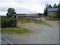
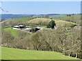
Pentre Farm on the Glyndŵr's Way
Pentre Farm, near Dolanog, stands on Glyndŵr's Way (sign in foreground). Glyndŵr's Way http://www.nationaltrail.co.uk/GlyndwrsWay/ is a new National Trail, opened in the year 2000, which runs from Knighton to Welshpool on a dog-leg course via Machynlleth. It is so named after the Welsh folk hero, Owain Glyndŵr; the path takes in some of the finest scenery in mid-Wales.
Image: © Oliver Dixon
Taken: 14 Sep 2007
0.04 miles
2
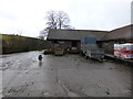
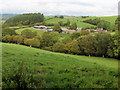
Part of the farmyard at Pentre farm
The farm dog come out and meets us.
Image: © Jeremy Bolwell
Taken: 23 Feb 2014
0.05 miles