IMAGES TAKEN NEAR TO
Aberllefenni, MACHYNLLETH, SY20 9RP
Introduction
This page details the photographs taken nearby to SY20 9RP by members of the Geograph project.
The Geograph project started in 2005 with the aim of publishing, organising and preserving representative images for every square kilometre of Great Britain, Ireland and the Isle of Man.

There are currently over 7.5m images from over14,400 individuals and you can help contribute to the project by visiting https://www.geograph.org.uk
Image Map
Images are licensed for reuse under creativecommons.org/licenses/by-sa/2.0
Notes
- Clicking on the map will re-center to the selected point.
- The higher the marker number, the further away the image location is from the centre of the postcode.
Image Listing (11 Images Found)
Images are licensed for reuse under creativecommons.org/licenses/by-sa/2.0
Image
Details
Distance
1
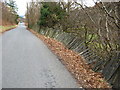
Collapsing fence near Corris
Slate fences are rot-proof, but not gravity proof - the weight of the slabs is too much for the soft verge.
Image: © David Medcalf
Taken: 23 Feb 2009
0.06 miles
3
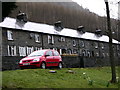
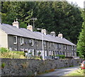
Cottages at Garneddwen
Garneddwen
A row of cottages built of the local slate in Cwm Dulas northeast of Corris
Image: © liz dawson
Taken: 29 Mar 2008
0.11 miles
4
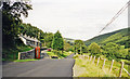
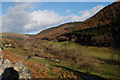
Site of Garneddwen station
View NE up the Afon Dulas valley, towards Aberllefeni. Until closed from 21/8/48 (passengers from 1/1/31), the narrow-gauge Corris Railway on its way from Machynlleth to Aberllefeni ran parallel to the road and crossed it here, but it is uncertain whether Garneddwen station was on the left or right.
(Update August 2020 - The 1901 OS 1:2,500 scale map shows that the station buildings, such as they were, were located on the left side of the railway and road here. The map also shows that the railway passed immediately to the right of the front garden walls, along what is now the road with the red car.)
Image: © Ben Brooksbank
Taken: 12 Sep 1999
0.13 miles
5
Garneddwen
A row of cottages built of the local slate in Cwm Dulas northeast of Corris
Image: © Roger W Haworth
Taken: 25 Jul 2006
0.13 miles
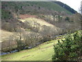
6
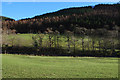
The Dulas valley above Corris
An attractive place on a sunny day, it consists mainly of fields by the river with forestry on steeper ground.
Image: © Nigel Brown
Taken: 29 Jan 2010
0.14 miles
7
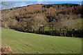
Fields by the Afon Dulas
A welcome contrast to the forestry.
Image: © Nigel Brown
Taken: 29 Jan 2010
0.18 miles
9
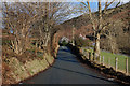
Minor road heading for Aberllefenni
Of varying widths, here it is getting narrower.
Image: © Nigel Brown
Taken: 29 Jan 2010
0.22 miles
10
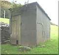
Slate shed at Caecernau
This farm building is made of a timber frame to which are nailed rectangular sheets of slate about 3/4" thick. The roof is made of "slates" of a similar thickness. The stone probably came from the nearby Aberllefenni quarries.
Image: © starkderrick
Taken: 16 Oct 2011
0.23 miles