IMAGES TAKEN NEAR TO
Darowen, MACHYNLLETH, SY20 8LP
Introduction
This page details the photographs taken nearby to SY20 8LP by members of the Geograph project.
The Geograph project started in 2005 with the aim of publishing, organising and preserving representative images for every square kilometre of Great Britain, Ireland and the Isle of Man.

There are currently over 7.5m images from over14,400 individuals and you can help contribute to the project by visiting https://www.geograph.org.uk
Image Map
Images are licensed for reuse under creativecommons.org/licenses/by-sa/2.0
Notes
- Clicking on the map will re-center to the selected point.
- The higher the marker number, the further away the image location is from the centre of the postcode.
Image Listing (5 Images Found)
Images are licensed for reuse under creativecommons.org/licenses/by-sa/2.0
Image
Details
Distance
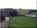
2
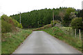
Road in Cwm Berllan
Heading towards Commins Coch from Darowen; it's the main approach to Darowen from the north.
Image: © Nigel Brown
Taken: 22 Apr 2009
0.14 miles
3
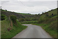
Road in Cwm Berllan
Looking towards the corner at which the narrow road to Abercegir branches off.
Image: © Nigel Brown
Taken: 22 Apr 2009
0.19 miles
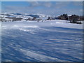
4
The fire's been lit at Ty-nant
Across the valley of the Nant Cegir, to the hills north of Ty-nant farm.
Image: © Richard Law
Taken: 2 Dec 2011
0.20 miles
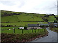
5
Fferm ger Darowen / Farm near Darowen
Fferm rhwng Darowen a Comins Coch / Farm between Darowen and Comins Coch.
Image: © Ian Medcalf
Taken: 29 Dec 2007
0.22 miles