IMAGES TAKEN NEAR TO
David Williams Court, MACHYNLLETH, SY20 8JU
Introduction
This page details the photographs taken nearby to David Williams Court, SY20 8JU by members of the Geograph project.
The Geograph project started in 2005 with the aim of publishing, organising and preserving representative images for every square kilometre of Great Britain, Ireland and the Isle of Man.

There are currently over 7.5m images from over14,400 individuals and you can help contribute to the project by visiting https://www.geograph.org.uk
Image Map
Images are licensed for reuse under creativecommons.org/licenses/by-sa/2.0
Notes
- Clicking on the map will re-center to the selected point.
- The higher the marker number, the further away the image location is from the centre of the postcode.
Image Listing (213 Images Found)
Images are licensed for reuse under creativecommons.org/licenses/by-sa/2.0
Image
Details
Distance
1
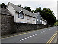
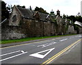
Houses behind a stone wall, Machynlleth
Viewed across the A487 Heol Pentrerhedyn.
Image: © Jaggery
Taken: 8 Oct 2016
0.00 miles
2
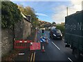
Temporary traffic lights on the A487 near Machynlleth
Image: © Steven Brown
Taken: 28 Oct 2022
0.01 miles
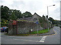
3
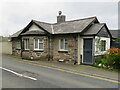
Lledfair Tollhouse, Aberystwyth Road, Machynlleth
Lledfair Tollhouse is situated on the A487 Aberystwyth Road, Machynlleth and was variously called Talbot Gate and Lledfair Cottage on old maps. The Machynlleth toll houses were no longer required from 12th May 1882 when the local highways board was set up. For more information see Image
Milestone Society National ID: POW.MAC01
Image: © John S Turner
Taken: 22 Mar 2019
0.01 miles
4
Lledfair Tollhouse
A former tollhouse on the road in/out of Mach from the Aberystwyth direction, and now converted to a private residence. It is mentioned (and photographed) on the Coflein website of the Royal Commission on the Ancient and Historical Monuments of Wales, but little other detail is provided there.
Image: © Richard Law
Taken: 29 Apr 2016
0.01 miles
5
Lledfair Tollhouse, Machynlleth
Now a private residence, the former tollhouse is alongside the A487 Aberystwyth Road.
Image: © Jaggery
Taken: 28 Mar 2012
0.01 miles
6
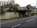
Lledfair Tollhouse, Machynlleth
Now a private residence, the former tollhouse is alongside what is now the A487.
Various tolls for passing through the town by road were formerly levied by
the Lord of the Manor and collected at this and several other tollhouses in Machynlleth.
The Coflein website records that Machynlleth's turnpike gates and the need for the toll houses disappeared on May 12th 1882, when a local Highway Board became responsible for road maintenance and improvement. On March 28th 1885, a sum of £100 was collected by subscription by the townsfolk to be paid to the Lord of the Manor to mark the end of toll collection.
Image: © Jaggery
Taken: 8 Oct 2016
0.01 miles
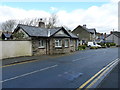
7
Grade II listed former coach house and stables, Machynlleth
The north side of the former Plas Machynlleth coach house and stables, viewed across the A487 Heol Pentrerhedyn. Probably dating from the earlier 19th century, Grade II listed in 1990.
Image: © Jaggery
Taken: 8 Oct 2016
0.02 miles
8
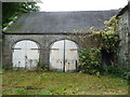
Old coach house doors at Y Plas, Machynlleth
Old doors that speak of a past age and modes of transport for the fortunate few.
Image: © Jeremy Bolwell
Taken: 28 Aug 2012
0.02 miles
9
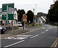
A487 directions sign, Machynlleth
On the approach to three mini-roundabouts. The first two of these are ahead on the right.
Image: © Jaggery
Taken: 8 Oct 2016
0.03 miles
10
Outbuildings at Y Plas, Machynlleth
Old disused coach house or car parking garages off a modern council car park.
Image: © Jeremy Bolwell
Taken: 28 Aug 2012
0.03 miles