IMAGES TAKEN NEAR TO
Treowain, MACHYNLLETH, SY20 8EH
Introduction
This page details the photographs taken nearby to Treowain, SY20 8EH by members of the Geograph project.
The Geograph project started in 2005 with the aim of publishing, organising and preserving representative images for every square kilometre of Great Britain, Ireland and the Isle of Man.

There are currently over 7.5m images from over14,400 individuals and you can help contribute to the project by visiting https://www.geograph.org.uk
Image Map
Images are licensed for reuse under creativecommons.org/licenses/by-sa/2.0
Notes
- Clicking on the map will re-center to the selected point.
- The higher the marker number, the further away the image location is from the centre of the postcode.
Image Listing (58 Images Found)
Images are licensed for reuse under creativecommons.org/licenses/by-sa/2.0
Image
Details
Distance
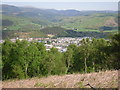
1
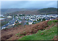
Machynlleth from Parc Common
Overlooking the east part of the town from a hillside near the golf course.
Image: © Andrew Hill
Taken: 20 Nov 2009
0.02 miles
2
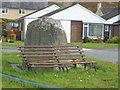
Bench and Rock
Monument in Machynlleth's Housing Circle
Image: © Finlay Cox
Taken: 30 Sep 2011
0.04 miles
3
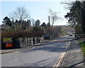
Forge Road, Machynlleth
Forge Road heads SE away from the A489 towards Treowain.
Image: © Jaggery
Taken: 28 Mar 2012
0.04 miles
4
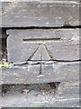
Ordnance Survey Cut Mark
This OS cut mark can be found on the wall of Rhosilly House, Newtown Road. It marks a point 20.763m above mean sea level.
Image: © Adrian Dust
Taken: 14 Jun 2014
0.10 miles
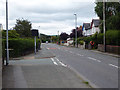
5

Roadworks on Newtown Road, Machynlleth
This is one of numerous sets of traffic light-controlled roadworks in Mid Wales on this day.
Image: © Bill Boaden
Taken: 25 Feb 2011
0.10 miles
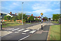
7
The A489 road leaving Machynlleth
A relatively short trunk road which joins Machynlleth to the A470 arterial road at Cemmaes Road. It contains two short stretches of the Glyndŵr's Way long-distance path.
Image: © John Lucas
Taken: 28 Aug 2018
0.11 miles
8
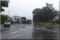
A489 in pouring rain
Looking across Heol Maengwyn in Machynlleth on a wet Sunday evening.
Image: © DS Pugh
Taken: 29 Jul 2018
0.12 miles
9

Gallt y Gog and Machynlleth suburbs
Housing on the edge of Machynlleth. Gallt y Gog (Cuckoo Hill) is in the background.
Image: © John Winder
Taken: 30 May 2015
0.13 miles
10
Machynlleth
A view overlooking Machynlleth and the hills beyond from near Llyn Glanmerin.
Image: © Peter S
Taken: 11 May 2009
0.13 miles