IMAGES TAKEN NEAR TO
Staylittle, LLANBRYNMAIR, SY19 7DB
Introduction
This page details the photographs taken nearby to SY19 7DB by members of the Geograph project.
The Geograph project started in 2005 with the aim of publishing, organising and preserving representative images for every square kilometre of Great Britain, Ireland and the Isle of Man.

There are currently over 7.5m images from over14,400 individuals and you can help contribute to the project by visiting https://www.geograph.org.uk
Image Map
Images are licensed for reuse under creativecommons.org/licenses/by-sa/2.0
Notes
- Clicking on the map will re-center to the selected point.
- The higher the marker number, the further away the image location is from the centre of the postcode.
Image Listing (16 Images Found)
Images are licensed for reuse under creativecommons.org/licenses/by-sa/2.0
Image
Details
Distance
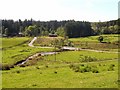
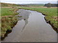
1
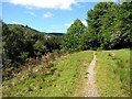
Bridleway above the Afon Llwyd
This bridleway runs along the north bank for a kilometre before crossing the stream into Hafren Forest.
Image: © Oliver Dixon
Taken: 12 Jun 2010
0.09 miles
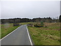
3
The bridge at Dolydd
Over the Afon Lwyd.
Image: © Nigel Brown
Taken: 3 Jun 2010
0.21 miles
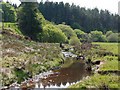
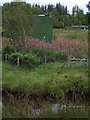
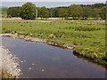
4
View from Dolydd Bridge: Afon Lwyd and lime doser
The river marks the divide between forest and farmland. The apparatus in the metal cage in the water on the left comprises an acidity sensor and a pipe connected to a nearby lime doser. If the water becomes too acidic (due to acid rain), limestone powder is automatically released into the river to help restore the natural balance and protect plants and wildlife.
Image: © John Gibson
Taken: 29 Dec 2008
0.21 miles
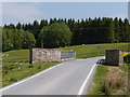
5
Bridge over the Afon Lwyd
This bridge at Dolydd carries the minor road through Hafren Forest across the Afon Lwyd a short way above where it flows into the Clywedog Reservoir.
Image: © Oliver Dixon
Taken: 12 Jun 2010
0.21 miles
6
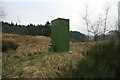
Lime doser, Dolydd
This lime doser beside the bridge at Dolydd is used to counter excess acidity in the Afon Lwyd, caused in the main by acid rain. Completely automatic, it adds measured doses of limestone powder to the river to neutralise excess acidity and thereby protect indigenous plants and wildlife.
Image: © John Gibson
Taken: 29 Dec 2008
0.22 miles
7
Lime doser, Dolydd
The doser releases lime into the Afon Lwyd in the foreground, to counter excess acidity.
Image: © Chris Andrews
Taken: 18 Aug 2011
0.22 miles
8
Bridge over the Afon Clywedog near Staylittle
With a lime doser that automatically adds lime to the acidic waters to improve the waters for nature and farming.
Image: © Jeremy Bolwell
Taken: 12 Apr 2014
0.23 miles
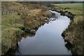
9
Part of the Afon Clywedog near Staylittle from Glyndwr's Way
Clear waters today.
Image: © Jeremy Bolwell
Taken: 12 Apr 2014
0.24 miles
10
Afon Lwyd
In its final stage meandering towards Llyn Clywedog.
Image: © Nigel Brown
Taken: 3 Jun 2010
0.24 miles