IMAGES TAKEN NEAR TO
Pennant, LLANBRYNMAIR, SY19 7BJ
Introduction
This page details the photographs taken nearby to SY19 7BJ by members of the Geograph project.
The Geograph project started in 2005 with the aim of publishing, organising and preserving representative images for every square kilometre of Great Britain, Ireland and the Isle of Man.

There are currently over 7.5m images from over14,400 individuals and you can help contribute to the project by visiting https://www.geograph.org.uk
Image Map
Images are licensed for reuse under creativecommons.org/licenses/by-sa/2.0
Notes
- Clicking on the map will re-center to the selected point.
- The higher the marker number, the further away the image location is from the centre of the postcode.
Image Listing (10 Images Found)
Images are licensed for reuse under creativecommons.org/licenses/by-sa/2.0
Image
Details
Distance
1
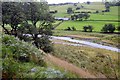
Opposite Hendre
Looking towards the buildings at Hendre from the footpath which runs south along the Afon Twymyn.
Image: © Trevor Harris
Taken: 1 Aug 2009
0.04 miles
2
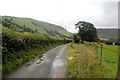
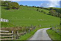
Lane near Hendre
Having passed through the farmyard at Pennant-isaf, the lane continues past an isolated cottage at Hendre towards the farm at Cilcwm.
Image: © Trevor Harris
Taken: 1 Aug 2009
0.11 miles
3
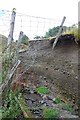
Footpath washed out
This little stream joining Afon Twymyn has recently washed out the footpath, leaving the fence and posts (one with the waymarker on it) dangling in mid-air. It has left this section very hard to negotiate. The subsoil is loose shale and slate chippings - very easily eroded.
Image: © Trevor Harris
Taken: 1 Aug 2009
0.16 miles
4
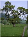
Pentre Cilcwm in Cwm Twymyn
One of many isolated trees amongst enclosed grazing land in the valley floor of Cwm Twymyn (Image), just upwards of Pentre Cilcwm.
Image: © Rudi Winter
Taken: 11 May 2008
0.17 miles
6
Afon Twymyn
Afon Twymyn seen from the bridge at Cilcwm.
Image: © Trevor Harris
Taken: 1 Aug 2009
0.23 miles
7
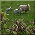
Sheep at Pennant Isaf
Looking rather alert and not sheepish at all!
Image: © Rudi Winter
Taken: 11 May 2008
0.23 miles
8
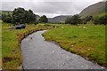
The Afon Twymyn near Pentre Cilcwm
Looking up the river, with the gorge at the head of the valley visible in the distance.
Image: © Nigel Brown
Taken: 13 May 2014
0.23 miles
9
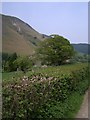
By the side of the Afon Twymyn
At the bottom of the steep-sided Cwm Twymyn (Image) are fields used for sheep and cattle grazing. The hedge frames the track from Pennant (the village, Image) to Pennant Isaf (the farm, Image).
Image: © Rudi Winter
Taken: 11 May 2008
0.24 miles
10
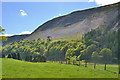
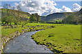
Looking across the Twymyn valley
On the other side, native woodland lies under the crags of Creigiau Pennant.
Image: © Nigel Brown
Taken: 13 May 2014
0.24 miles