IMAGES TAKEN NEAR TO
SY19 7AU
Introduction
This page details the photographs taken nearby to SY19 7AU by members of the Geograph project.
The Geograph project started in 2005 with the aim of publishing, organising and preserving representative images for every square kilometre of Great Britain, Ireland and the Isle of Man.

There are currently over 7.5m images from over14,400 individuals and you can help contribute to the project by visiting https://www.geograph.org.uk
Image Map
Images are licensed for reuse under creativecommons.org/licenses/by-sa/2.0
Notes
- Clicking on the map will re-center to the selected point.
- The higher the marker number, the further away the image location is from the centre of the postcode.
Image Listing (5 Images Found)
Images are licensed for reuse under creativecommons.org/licenses/by-sa/2.0
Image
Details
Distance
2
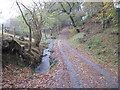
The track to Cwm yr hun
At this point the public bridleway diverges to the left of the photo and is almost impassable due to brambles and fallen trees.
Image: © David Medcalf
Taken: 9 Nov 2009
0.14 miles
5
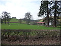
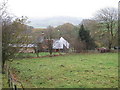
Sheep pasture in front of Dolgadfan in spring
A more idyllic scene in Mid Wales would be hard to picture; ewes with their new born lambs doze in the fitful sunshine of the 'first day of spring', the vernal equinox.
The curves of the hills, the way the landscape has evolved and the old farmhouse complete an almost perfect scene, to my eye anyway.
Image: © Jeremy Bolwell
Taken: 20 Mar 2012
0.23 miles