IMAGES TAKEN NEAR TO
Llangurig, LLANIDLOES, SY18 6SA
Introduction
This page details the photographs taken nearby to SY18 6SA by members of the Geograph project.
The Geograph project started in 2005 with the aim of publishing, organising and preserving representative images for every square kilometre of Great Britain, Ireland and the Isle of Man.

There are currently over 7.5m images from over14,400 individuals and you can help contribute to the project by visiting https://www.geograph.org.uk
Image Map
Images are licensed for reuse under creativecommons.org/licenses/by-sa/2.0
Notes
- Clicking on the map will re-center to the selected point.
- The higher the marker number, the further away the image location is from the centre of the postcode.
Image Listing (9 Images Found)
Images are licensed for reuse under creativecommons.org/licenses/by-sa/2.0
Image
Details
Distance
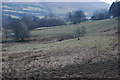
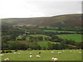
2
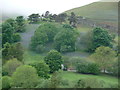
Bluebells across the Wye Valley in May
A large swathe of bluebells clothes the south facing tip of Esgair y Craig. What a spot.
Image: © Jeremy Bolwell
Taken: 31 May 2012
0.09 miles
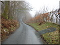
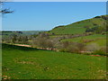
3
Grazing land near Pant-y-drain
Mainly reasonable grazing with some damper patches. The farm can be just seen on the right.
Image: © Nigel Brown
Taken: 6 Feb 2010
0.12 miles
4
Tir Amaethyddol ger Dolfach/ Farmland near Dolfach
Tir Amaethyddol ger Dolfach yn Nyffryn Gwy / Farmland near Dolfach in the Wye Valley.
Image: © Ian Medcalf
Taken: 19 Apr 2009
0.14 miles
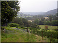
5
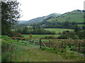
Farmland in the upper Wye Valley
Viewed from the lane which runs from Llangurig to Dernol. The River Wye (Afon Gwy) is marked by the line of trees which runs horizontally across the centre of the picture. The buildings in the middle distance are at Dolfach-isaf which stands beside the A44 road.
Image: © John Lucas
Taken: 30 Sep 2006
0.17 miles
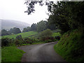
6
A view across the Wye Valley
The coach in view is on the A44 road. Beyond that, the track to Dolfach can be seen climbing the hill.
Image: © John Lucas
Taken: 30 Sep 2006
0.22 miles
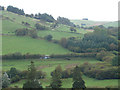
7
Farmland at Pant-y-drain
Looking eastwards across the Wye Valley. Turbines at the Bryn Titli Wind Farm are visible on the horizon.
Image: © John Lucas
Taken: 30 Sep 2006
0.23 miles