IMAGES TAKEN NEAR TO
Maesyllan, LLANIDLOES, SY18 6RW
Introduction
This page details the photographs taken nearby to Maesyllan, SY18 6RW by members of the Geograph project.
The Geograph project started in 2005 with the aim of publishing, organising and preserving representative images for every square kilometre of Great Britain, Ireland and the Isle of Man.

There are currently over 7.5m images from over14,400 individuals and you can help contribute to the project by visiting https://www.geograph.org.uk
Image Map
Images are licensed for reuse under creativecommons.org/licenses/by-sa/2.0
Notes
- Clicking on the map will re-center to the selected point.
- The higher the marker number, the further away the image location is from the centre of the postcode.
Image Listing (99 Images Found)
Images are licensed for reuse under creativecommons.org/licenses/by-sa/2.0
Image
Details
Distance
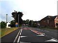
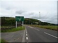
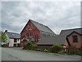
1
Trains and cars no more!/Dim mwy o drenau neu geir!
Since the bypass was built, this section of the old road to Llanidloes provides access only to a farm. To the left, sheep are walking along the embankment of the ill-fated Manchester & Milford Railway, construction of which was abandoned at Llangurig.
Image: © Tiger
Taken: 11 Mar 2012
0.02 miles
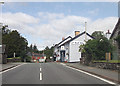
2
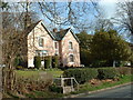
The Old Vicarage
Now a very pleasant guest house. The church is some distance from this house.
Image: © David Medcalf
Taken: 16 Mar 2007
0.03 miles
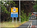
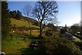
3
Eastern approach to Llangurig station site
The northern arm of the Manchester and Milford Railway approached Llangurig on a rising gradient, before reaching the station site through this cutting.
The trackbed from the A470 to this point is now a public footpath.
Image: © Nigel Brown
Taken: 31 Dec 1998
0.04 miles
4
Ebenezer chapel, Llangurig
A centrally located redbrick and slate chapel dated 1904.
Image: © Jeremy Bolwell
Taken: 13 Jun 2012
0.05 miles
5
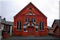
Ebenezer
Adeiladwyd y capel hwn gan y Methodistiaid Calfinaidd yn 1904.
This chapel was built by the Calvinistic Methodists in 1904.
Image: © Tiger
Taken: 10 Mar 2012
0.05 miles