IMAGES TAKEN NEAR TO
Van, LLANIDLOES, SY18 6NU
Introduction
This page details the photographs taken nearby to SY18 6NU by members of the Geograph project.
The Geograph project started in 2005 with the aim of publishing, organising and preserving representative images for every square kilometre of Great Britain, Ireland and the Isle of Man.

There are currently over 7.5m images from over14,400 individuals and you can help contribute to the project by visiting https://www.geograph.org.uk
Image Map
Images are licensed for reuse under creativecommons.org/licenses/by-sa/2.0
Notes
- Clicking on the map will re-center to the selected point.
- The higher the marker number, the further away the image location is from the centre of the postcode.
Image Listing (183 Images Found)
Images are licensed for reuse under creativecommons.org/licenses/by-sa/2.0
Image
Details
Distance
1
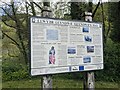
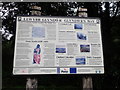
Information board at Clywedog car park
The long distance Glyndŵr's Way footpath passes through Clywedog reservoir.
Image: © Fabian Musto
Taken: 4 Jun 2021
0.01 miles
2
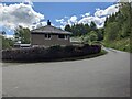
Clywedog car park
The free car park here is placed by Clywedog Reservoir, and some houses from the mid 20th century are adjacent to the car park.
Image: © Fabian Musto
Taken: 4 Jun 2021
0.01 miles
3
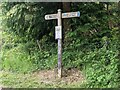
Fingerposts at Clywedog car park
These fingerposts are on the Glyndŵr's Way footpath, and informs the visitors at Clywedog car park that they're on the long-distance public footpath.
Image: © Fabian Musto
Taken: 4 Jun 2021
0.01 miles
4
Information board at Clywedog car park
This information board is placed by the free car park for visitors seeing the Clywedog Reservoir.
Image: © Fabian Musto
Taken: 4 Jun 2021
0.01 miles
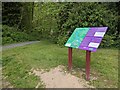
5
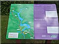
Information board, Glyndwr's Way
A wealth of information about this National Trail at the parking area near Bryntail Lead Mines.
Image: © Eirian Evans
Taken: 24 Aug 2020
0.01 miles
6
Information board at Clywedog car park
This information board is placed by the free car park for visitors seeing the Clywedog Reservoir.
Image: © Fabian Musto
Taken: 4 Jun 2021
0.01 miles
7
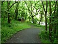
Path down to Afon Clywedog and Bryntail Mine
Part of Glyndwr's Way.
Image: © Christine Johnstone
Taken: 19 Jun 2016
0.02 miles
8
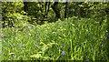
Bluebells by the River Clywedog
These bluebells were by the River Clywedog on the path to Clywedog car park when I visited.
Image: © Fabian Musto
Taken: 4 Jun 2021
0.02 miles
9
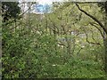
Forest at Clywedog Reservoir
Many trees plaster this view of the dam and remains of Bryntail lead mine at Clywedog Reservoir.
Image: © Fabian Musto
Taken: 4 Jun 2021
0.03 miles
10
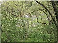
Trees outside Bryntail lead mine
The remains of Bryntail lead mine can briefly be seen in the distance.
Image: © Fabian Musto
Taken: 4 Jun 2021
0.03 miles