IMAGES TAKEN NEAR TO
Llidiartywaun, LLANIDLOES, SY18 6JX
Introduction
This page details the photographs taken nearby to SY18 6JX by members of the Geograph project.
The Geograph project started in 2005 with the aim of publishing, organising and preserving representative images for every square kilometre of Great Britain, Ireland and the Isle of Man.

There are currently over 7.5m images from over14,400 individuals and you can help contribute to the project by visiting https://www.geograph.org.uk
Image Map
Images are licensed for reuse under creativecommons.org/licenses/by-sa/2.0
Notes
- Clicking on the map will re-center to the selected point.
- The higher the marker number, the further away the image location is from the centre of the postcode.
Image Listing (4 Images Found)
Images are licensed for reuse under creativecommons.org/licenses/by-sa/2.0
Image
Details
Distance
1
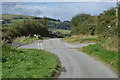
Crossroads
On the road to Llidiartywaun. The road off left connects with the Tylwch to Pantydwr road; being narrow, with sharp corners and few passing places, heavy vehicles are discouraged. The road off right gives access to a few hill farms.
Image: © Nigel Brown
Taken: 18 Sep 2012
0.06 miles
3
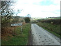
Mystery village
Llidiartywaen must be the name of the area, but it doesn't feature on the OS maps [as far as I could see].
Image: © David Medcalf
Taken: 17 Mar 2007
0.20 miles