IMAGES TAKEN NEAR TO
Glandwr Terrace, CAERSWS, SY17 5QF
Introduction
This page details the photographs taken nearby to Glandwr Terrace, SY17 5QF by members of the Geograph project.
The Geograph project started in 2005 with the aim of publishing, organising and preserving representative images for every square kilometre of Great Britain, Ireland and the Isle of Man.

There are currently over 7.5m images from over14,400 individuals and you can help contribute to the project by visiting https://www.geograph.org.uk
Image Map
Images are licensed for reuse under creativecommons.org/licenses/by-sa/2.0
Notes
- Clicking on the map will re-center to the selected point.
- The higher the marker number, the further away the image location is from the centre of the postcode.
Image Listing (9 Images Found)
Images are licensed for reuse under creativecommons.org/licenses/by-sa/2.0
Image
Details
Distance
1
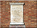
Gleiniant Methodist Chapel
A close-up of the plaque on the chapel.
Image: © John Lucas
Taken: 18 Feb 2006
0.06 miles
2
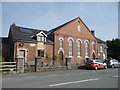
Old chapel and school at Gleiniant near Trefeglwys
Now apparently converted into a home or homes.
Image: © Jeremy Bolwell
Taken: 21 Jul 2012
0.06 miles
3
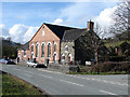
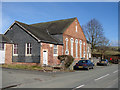
Methodist Chapel, Gleiniant, Trefeglwys
The plaque at the top of the chapel carries the inscription: "Gleiniant Calvinistic Methodist Chapel, Erected 1823. Re-erected 1870". Adjoining the left of the chapel, furthest from the camera, is a British Schools' classroom, erected 1865. A lot of history here!
Image: © John Lucas
Taken: 18 Feb 2006
0.06 miles
4
Old school and chapel at Gleiniant
Now apparently undergoing conversion to a private house.
Image: © Oliver Dixon
Taken: 24 Jul 2008
0.06 miles
5

Entering Trefeglwys
With Gleiniant Calvinistic Methodist Chapel and its associated British School prominent in the view.
Image: © John Lucas
Taken: 18 Feb 2006
0.07 miles
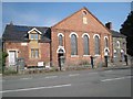
6
Gleiniant Chapel and British School
The school is the annex at this end of the building. The chapel dates from 1823 (rebuilt 1870) and the school from 1865.
Image: © John Lucas
Taken: 18 Feb 2006
0.08 miles
7
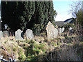
Overgrown cemetery in Trefeglwys
Probably associated with the nearby Gleiniant Methodist chapel.
Image: © John Lucas
Taken: 18 Feb 2006
0.10 miles
8
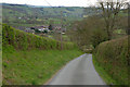
Road descending south to Trefeglwys
With the village seen ahead.
Image: © Nigel Brown
Taken: 28 Apr 2010
0.17 miles
9
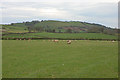
Field by Trefeglwys
Level grazing on the valley floor.
Image: © Nigel Brown
Taken: 28 Apr 2010
0.25 miles