IMAGES TAKEN NEAR TO
Station Road, CAERSWS, SY17 5NA
Introduction
This page details the photographs taken nearby to Station Road, SY17 5NA by members of the Geograph project.
The Geograph project started in 2005 with the aim of publishing, organising and preserving representative images for every square kilometre of Great Britain, Ireland and the Isle of Man.

There are currently over 7.5m images from over14,400 individuals and you can help contribute to the project by visiting https://www.geograph.org.uk
Image Map
Images are licensed for reuse under creativecommons.org/licenses/by-sa/2.0
Notes
- Clicking on the map will re-center to the selected point.
- The higher the marker number, the further away the image location is from the centre of the postcode.
Image Listing (209 Images Found)
Images are licensed for reuse under creativecommons.org/licenses/by-sa/2.0
Image
Details
Distance
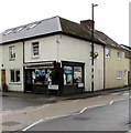
1
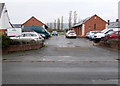
Caersws Workshops, Caersws
On the north side of Station Road.
Image: © Jaggery
Taken: 4 Nov 2015
0.01 miles
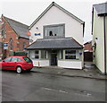
2
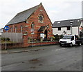
The Methodist Church, Caersws
The church is on the north side of Station Road. The Welshpool and Bro Hafren Methodist Circuit website records that the Methodist cause in Caersws dates from 1799, when the congregation gathered at premises near the entrance to a riverside recreation ground. The site was prone to flooding, so in 1874 a new chapel was built on its present site. It was established as an English (language) Church attached to the Newtown Circuit, with a minister resident in the village. The English cause then became defunct, but with the onset of the religious revival of 1904 it was reopened in 1912. This was as a Welsh-preaching church attached to the Llanidloes Circuit. From this time it has continued to hold regular services. In 2015 English is the language of worship.
Image: © Jaggery
Taken: 4 Nov 2015
0.01 miles
3
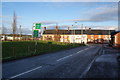
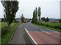
Trefeglwys Road, Caersws
Shortly to meet the A470, the main road which zigzags up most of Wales.
Image: © Bill Boaden
Taken: 15 Jan 2013
0.01 miles
4
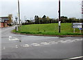
Caersws 4 miles from Trefeglwys
The sign on the corner of the A470 Carno Road in Caersws points left towards the B4569 Trefeglwys Road. http://www.geograph.org.uk/photo/4731747
Image: © Jaggery
Taken: 4 Nov 2015
0.02 miles
5
Caersws Fish Bar, Caersws
The Station Road fish & chips shop is next door to the Methodist Church. http://www.geograph.org.uk/photo/4730870
Image: © Jaggery
Taken: 4 Nov 2015
0.02 miles
6
Southern end of Carno Road, Caersws
The A470 Bridge Street behind the camera becomes the A470 Carno Road ahead.
Viewed from the corner of Main Street, where a sign shows 3 (miles) to Aberhafesp.
Image: © Jaggery
Taken: 4 Nov 2015
0.02 miles
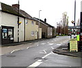
7
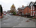
Corner of Station Road and Carno Road, Caersws
The name on the corner shop is Alun W.Owen family butchers. Station Road is on the left.
Image: © Jaggery
Taken: 4 Nov 2015
0.03 miles
8
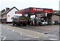
Texaco filling station, Caersws
Texaco filling station and Costcutter shop viewed across Carno Road.
Image: © Jaggery
Taken: 4 Nov 2015
0.03 miles
9
Part of Caersws
The A470 road runs through Caersws here. But the main town is set either side of this trunk road and I was struck by what a genuinely friendly community this small town seems to have ; I saw several people greeting each other warmly and immediately indulging in conversations that lasted many minutes, there were no deserted streets or that dormer-town feel that you get in all too many places during the day.
Image: © Jeremy Bolwell
Taken: 25 Aug 2010
0.03 miles
10
Station Road, Caersws
Looking along Station Road towards the Carno Road, Main Street and Bridge Street crossroads.
Image: © Jaggery
Taken: 4 Nov 2015
0.03 miles