1
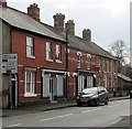
The Old Stores in Caersws
The shop front remains, but all the trade is now with the Spar shop at the crossroads just along the road.
Image: © Oliver Dixon
Taken: 23 Jul 2008
0.01 miles
2
Direction sign, Main Street, Caersws
At the A470 junction 75 metres ahead, turn left for Llangurig and Newtown, right for Dolgellau and Machynlleth.
Image: © Jaggery
Taken: 4 Nov 2015
0.02 miles
3
National Playing Fields Association plaque, Caersws
The undated plaque is on the side of a bus shelter http://www.geograph.org.uk/photo/4728782, facing this http://www.geograph.org.uk/photo/4728762 playground.
Image: © Jaggery
Taken: 4 Nov 2015
0.02 miles
4
Bench on the back of a Main Street bus shelter, Caersws
Facing this http://www.geograph.org.uk/photo/4728762 children's playground.
A small green National Playing Fields Association plaque http://www.geograph.org.uk/photo/4728769 is on the side of the shelter.
Above the plaque, a notice shows Children's Playground No Dogs No Cycles.
Image: © Jaggery
Taken: 4 Nov 2015
0.02 miles
5
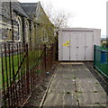
Caersws Village electricity substation
Set back from Main Street, between a church and a children's playground.
The electricity substation identifier is CAERSWS VILLAGE 09/0391/001
A small yellow caution label on the box shows the presence of SF6
(sulphur hexafluoride, an insulating gas used in high voltage systems).
Image: © Jaggery
Taken: 4 Nov 2015
0.02 miles
6
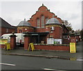
Caersws Village Hall
Image: © Eirian Evans
Taken: 1 Jul 2009
0.02 miles
7
Row of houses, Main Street, Caersws
Extending for 35 metres. The spire http://www.geograph.org.uk/photo/4738696 of Caersws Presbyterian Church is in the distance.
Image: © Jaggery
Taken: 4 Nov 2015
0.02 miles
8
Caersws Presbyterian Church
Image: © Eirian Evans
Taken: 1 Jul 2009
0.02 miles
9
Caersws Village Hall
Viewed across Main Street. Today, the village hall is the venue for Andrew Dowen's sale of home furnishings.
Image: © Jaggery
Taken: 4 Nov 2015
0.02 miles
10
The Buck, Caersws
On the Main Street in caersws, next to the Village Hall.
Image: © Eirian Evans
Taken: 1 Jul 2009
0.02 miles


