IMAGES TAKEN NEAR TO
LLANDINAM, SY17 5AQ
Introduction
This page details the photographs taken nearby to SY17 5AQ by members of the Geograph project.
The Geograph project started in 2005 with the aim of publishing, organising and preserving representative images for every square kilometre of Great Britain, Ireland and the Isle of Man.

There are currently over 7.5m images from over14,400 individuals and you can help contribute to the project by visiting https://www.geograph.org.uk
Image Map
Images are licensed for reuse under creativecommons.org/licenses/by-sa/2.0
Notes
- Clicking on the map will re-center to the selected point.
- The higher the marker number, the further away the image location is from the centre of the postcode.
Image Listing (7 Images Found)
Images are licensed for reuse under creativecommons.org/licenses/by-sa/2.0
Image
Details
Distance
1
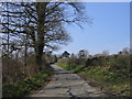
Lon Wledig ger Little London / Country Lane near Little London
Lon Wledig ger Little London gyda Bryn Helyg yn y pellter / Country Lane near Little London with Bryn Helyg in the distance.
Image: © Ian Medcalf
Taken: 2 Apr 2007
0.03 miles
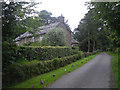
3
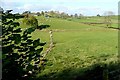
Upland fields below Bryn-helyg
Part of the undulating plateau between Mochdre and Caersws.
Image: © Bill Boaden
Taken: 15 Dec 2012
0.16 miles
5
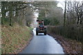
Welsh farmer between fields
He had made several trips back and forth, which included moving some bales.
Image: © Bill Boaden
Taken: 15 Dec 2012
0.23 miles
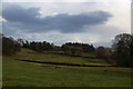
6
Towards The Forest
The Forest appears to be the name of the farm seen in the middle distance. These are the most northerly of the upland sheep pastures of the Waun Lluestowain plateau, before it drops into the Severn plain a mile north of here.
Image: © Graham Horn
Taken: 25 Oct 2009
0.24 miles
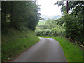
7
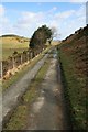
Lane across Penstrowed
This little-used and gated lane runs across the flank of Penstrowed Hill to descend via Maesmawr to the A489. At an elevation of around 300m, the hillsides are mainly given over to improved sheep pastures and were an area of early enclosures of moorland.
Image: © John Gibson
Taken: 21 Mar 2008
0.25 miles