IMAGES TAKEN NEAR TO
Kerry, NEWTOWN, SY16 4PQ
Introduction
This page details the photographs taken nearby to SY16 4PQ by members of the Geograph project.
The Geograph project started in 2005 with the aim of publishing, organising and preserving representative images for every square kilometre of Great Britain, Ireland and the Isle of Man.

There are currently over 7.5m images from over14,400 individuals and you can help contribute to the project by visiting https://www.geograph.org.uk
Image Map
Images are licensed for reuse under creativecommons.org/licenses/by-sa/2.0
Notes
- Clicking on the map will re-center to the selected point.
- The higher the marker number, the further away the image location is from the centre of the postcode.
Image Listing (3 Images Found)
Images are licensed for reuse under creativecommons.org/licenses/by-sa/2.0
Image
Details
Distance
1
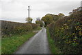
Lane near Drefor Farm
The farm can just be seen ahead. All the hedges have received their autumn trim, but they are still high enough to obscure any view.
Image: © Bill Boaden
Taken: 30 Oct 2014
0.18 miles
2
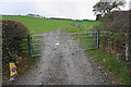
Field entrance near Drefor Farm
The cone suggests this field may have hosted a public event.
Image: © Bill Boaden
Taken: 30 Oct 2014
0.19 miles
3
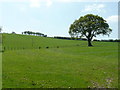
Oak tree and pasture
View south - uphill - from near Drefor Farm.
Image: © Jonathan Billinger
Taken: 14 May 2008
0.22 miles