IMAGES TAKEN NEAR TO
Kerry, NEWTOWN, SY16 4PH
Introduction
This page details the photographs taken nearby to SY16 4PH by members of the Geograph project.
The Geograph project started in 2005 with the aim of publishing, organising and preserving representative images for every square kilometre of Great Britain, Ireland and the Isle of Man.

There are currently over 7.5m images from over14,400 individuals and you can help contribute to the project by visiting https://www.geograph.org.uk
Image Map
Images are licensed for reuse under creativecommons.org/licenses/by-sa/2.0
Notes
- Clicking on the map will re-center to the selected point.
- The higher the marker number, the further away the image location is from the centre of the postcode.
Image Listing (5 Images Found)
Images are licensed for reuse under creativecommons.org/licenses/by-sa/2.0
Image
Details
Distance
1
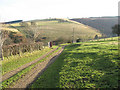
Farm road to Cwm
This farm track carries a footpath to the outlying farm at Cwm, where the forested slope can be seen in the right of the picture. The skyline is occupied by the Ceri Forest and Ridgeway path.
Image: © Jonathan Wilkins
Taken: 26 Dec 2008
0.10 miles
2
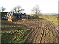
Silage store
A shallow quarry at the side of the farm track has been used to store silage and position feeding stalls. Low sun accentuates tracks in the ever-present mud.
Image: © Jonathan Wilkins
Taken: 26 Dec 2008
0.14 miles
3
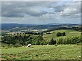
View from the lane near Kerry Pole
440 metres (1443 feet) above sea level.
Image: © Mat Fascione
Taken: 26 Jun 2022
0.23 miles
4
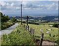
Lane near Kerry Pole
440 metres (1443 feet) above sea level.
Image: © Mat Fascione
Taken: 26 Jun 2022
0.23 miles
5
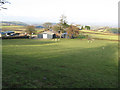
Pant y llidiart
A farm lying below the ridge of the Ceri Forest.
Image: © Jonathan Wilkins
Taken: 26 Dec 2008
0.24 miles