IMAGES TAKEN NEAR TO
Mochdre, NEWTOWN, SY16 4JR
Introduction
This page details the photographs taken nearby to SY16 4JR by members of the Geograph project.
The Geograph project started in 2005 with the aim of publishing, organising and preserving representative images for every square kilometre of Great Britain, Ireland and the Isle of Man.

There are currently over 7.5m images from over14,400 individuals and you can help contribute to the project by visiting https://www.geograph.org.uk
Image Map
Images are licensed for reuse under creativecommons.org/licenses/by-sa/2.0
Notes
- Clicking on the map will re-center to the selected point.
- The higher the marker number, the further away the image location is from the centre of the postcode.
Image Listing (1 Images Found)
Images are licensed for reuse under creativecommons.org/licenses/by-sa/2.0
Image
Details
Distance
1
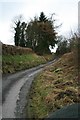
Lane near Llwyn-Madoc
This worn out old lane climbs westwards at around 1:5 to 1:6 passing the farm at Llwyn-Madoc and heading in the rough direction of Pentre. The road surface shows the effects of constant water flows and weathering, while the photo is taken from a point on the road which periodically needs to be forded.
Image: © John Gibson
Taken: 1 Jan 2008
0.23 miles