IMAGES TAKEN NEAR TO
Sarn, NEWTOWN, SY16 4HQ
Introduction
This page details the photographs taken nearby to SY16 4HQ by members of the Geograph project.
The Geograph project started in 2005 with the aim of publishing, organising and preserving representative images for every square kilometre of Great Britain, Ireland and the Isle of Man.

There are currently over 7.5m images from over14,400 individuals and you can help contribute to the project by visiting https://www.geograph.org.uk
Image Map
Images are licensed for reuse under creativecommons.org/licenses/by-sa/2.0
Notes
- Clicking on the map will re-center to the selected point.
- The higher the marker number, the further away the image location is from the centre of the postcode.
Image Listing (12 Images Found)
Images are licensed for reuse under creativecommons.org/licenses/by-sa/2.0
Image
Details
Distance
1
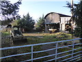
Corner of a farmyard
A slightly neglected corner maybe?
Image: © Jeremy Bolwell
Taken: 26 Dec 2016
0.04 miles
2
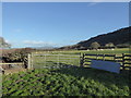
Sheep pasture at Bachaethlon, Powys
With a distant view to Corndon Hill.
Image: © Jeremy Bolwell
Taken: 26 Dec 2016
0.07 miles
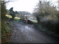
3
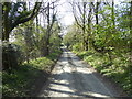
Lane and road bridge ahead
Hot walking.
Image: © Jeremy Bolwell
Taken: 20 Apr 2019
0.08 miles
4
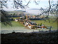
The settlement at Bachaethlon
Photographed from the public footpath on Hopton Uchaf hill.
Bachaethlon does not form part of 'The City' which is a very specific collection of houses in an almost closed dingle to the left of this picture. This name is probably C19th whereas the term Bachaethlon was a 'township' in the parish of Kerry, with references possibly as far back as the C14th.
The photo captures the probable lines of a mediaeval field system showing in the frosted ground to the immediate left of the first house. These lines are seen very rarely. On the right of the house immediately below are showing two probable boundaries (once hedges?) of uncertain age. In the field in which these are found is also evidence of ridge and furrow which show more clearly - even without frost or snow and further to the right of them (but obscured by the branch in the picture) are 'platforms' and ditches that indicate some form of settlement (again of uncertain age but probably mediaeval).
Thanks to Ian Ball for this local knowledge
Image: © Richard Law
Taken: 30 Nov 2008
0.10 miles
5
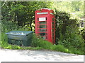
Coins Not Accepted
Its days are numbered! I guess.
Image: © Paul Beaman
Taken: 19 May 2008
0.13 miles
6
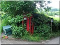
Telephone box at City
As predicted in Image, the days of this telephone box are certainly numbered. One of a number of telephone boxes located in isolated spots in the hill country of the Welsh Border. Even in its heyday, it was probably little-used and in these days of universal mobile phone ownership, it appears, judging by the vigorous growth of the surrounding vegetation, that it has not been used for weeks or even months. A notice inside invites local community organizations to conserve this iconic box by buying it for £1 (without the telephone); or alternatively subsidising the continued availability of a telephone service.
Image: © Oliver Dixon
Taken: 13 Jun 2010
0.14 miles
7
Dilapidated telephone box at City, Powys
In a much worse state than in the most recent geograph photo taken back in 2010 by Oliver Dixon http://www.geograph.org.uk/photo/1934090 here.
Image: © Jeremy Bolwell
Taken: 26 Dec 2016
0.14 miles
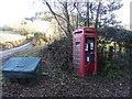
8
The telephone and post boxes of the City
Image: © Richard Law
Taken: 30 Nov 2008
0.16 miles
9
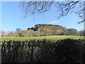
Field and wood near City, Powys
Lovely view on a sunny Boxing Day.
Image: © Jeremy Bolwell
Taken: 26 Dec 2016
0.17 miles
10
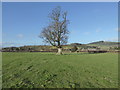
Tree in sheep pasture near Sarn, Powys
A summer shade producer.
Image: © Jeremy Bolwell
Taken: 26 Dec 2016
0.17 miles