IMAGES TAKEN NEAR TO
Kerry, NEWTOWN, SY16 4EG
Introduction
This page details the photographs taken nearby to SY16 4EG by members of the Geograph project.
The Geograph project started in 2005 with the aim of publishing, organising and preserving representative images for every square kilometre of Great Britain, Ireland and the Isle of Man.

There are currently over 7.5m images from over14,400 individuals and you can help contribute to the project by visiting https://www.geograph.org.uk
Image Map
Images are licensed for reuse under creativecommons.org/licenses/by-sa/2.0
Notes
- Clicking on the map will re-center to the selected point.
- The higher the marker number, the further away the image location is from the centre of the postcode.
Image Listing (3 Images Found)
Images are licensed for reuse under creativecommons.org/licenses/by-sa/2.0
Image
Details
Distance
1
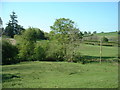
Farmland at Lower Trefeen
The A488 is just beyond the second field.
Image: © David Medcalf
Taken: 2 May 2007
0.03 miles

3
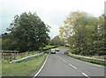
A489 East approaching bridge near Lower Trefeen
Road the corner is the road to Lower Trefeen. The overbridge where the railings are cross a small stream which joins the Afon Mule a few yards north
Image: © John Firth
Taken: 31 Oct 2011
0.13 miles