IMAGES TAKEN NEAR TO
Llanllwchaiarn, NEWTOWN, SY16 3BH
Introduction
This page details the photographs taken nearby to Llanllwchaiarn, SY16 3BH by members of the Geograph project.
The Geograph project started in 2005 with the aim of publishing, organising and preserving representative images for every square kilometre of Great Britain, Ireland and the Isle of Man.

There are currently over 7.5m images from over14,400 individuals and you can help contribute to the project by visiting https://www.geograph.org.uk
Image Map
Images are licensed for reuse under creativecommons.org/licenses/by-sa/2.0
Notes
- Clicking on the map will re-center to the selected point.
- The higher the marker number, the further away the image location is from the centre of the postcode.
Image Listing (45 Images Found)
Images are licensed for reuse under creativecommons.org/licenses/by-sa/2.0
Image
Details
Distance
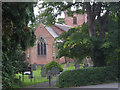
1
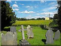
View east from the churchyard, Llanllwchaiarn Parish Church
This was a rare sunny day in June 2012 and I was out collecting elderflowers for cordial.
Image: © Penny Mayes
Taken: 25 Jun 2012
0.04 miles
2

Benchmark on Llanllwchaiarn Parish Church
On the north wall of the church towards the eastern end. Details of this cut mark may be found on the Bench Mark database here http://www.bench-marks.org.uk/bm33905 .
There is another cut mark on the tower - see http://www.geograph.org.uk/photo/1848887.
Image: © Penny Mayes
Taken: 25 Jun 2012
0.05 miles
3

Benchmark on Llanllwchaiarn Parish Church
On the north wall of the church towards the eastern end. Details of this cut mark may be found on the Bench Mark database here http://www.bench-marks.org.uk/bm33905 . For a closer view see http://www.geograph.org.uk/photo/3033771
There is another cut mark with bolt on the tower - see http://www.geograph.org.uk/photo/1848887
Image: © Penny Mayes
Taken: 25 Jun 2012
0.05 miles
4
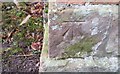
Ordnance Survey Cut Mark
This OS cut mark can be found on the NW face of St Llwchaiarn's Church. It marks a point 107.1208m above mean sea level.
Image: © Adrian Dust
Taken: 29 Jan 2017
0.05 miles
5
Llanllwchaiarn Parish Church
This brick-built Victorian church has a datestone of 1815 above its West door. It does not appear to have any dedication.
Image: © Penny Mayes
Taken: 17 Oct 2007
0.05 miles
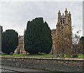
8
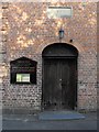
Llanllwchaiarn Parish Church - west door
The door at the foot of the tower. Note the date stone showing 1813 and the cut benchmark and bolt http://www.geograph.org.uk/photo/1848887 to the left of the door.
Image: © Penny Mayes
Taken: 12 Apr 2010
0.06 miles
9
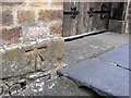
Benchmark on Llanllwchaiarn Parish Church
Beside the door at the foot of the tower.
A 1GL bolt mark which was levelled on the Worcester to Aberystwyth line during 1849-1855 survey. Details on the bench mark database http://www.bench-marks.org.uk/bm33906
For a wider view see Image
There is another cut mark on the NE corner of this church - see http://www.geograph.org.uk/photo/3033771
Image: © Penny Mayes
Taken: 12 Apr 2010
0.06 miles
10

Sun dial Llanllwchaiarn Parish Church
A rather scruffy wood and iron sun dial set in one of the round windows of the tower. Now rendered useless, except perhaps around midday in summer, by tall trees in the churchyard.
Image: © Penny Mayes
Taken: 25 Jun 2012
0.06 miles