IMAGES TAKEN NEAR TO
Aberbechan, NEWTOWN, SY16 3AP
Introduction
This page details the photographs taken nearby to SY16 3AP by members of the Geograph project.
The Geograph project started in 2005 with the aim of publishing, organising and preserving representative images for every square kilometre of Great Britain, Ireland and the Isle of Man.

There are currently over 7.5m images from over14,400 individuals and you can help contribute to the project by visiting https://www.geograph.org.uk
Image Map
Images are licensed for reuse under creativecommons.org/licenses/by-sa/2.0
Notes
- Clicking on the map will re-center to the selected point.
- The higher the marker number, the further away the image location is from the centre of the postcode.
Image Listing (5 Images Found)
Images are licensed for reuse under creativecommons.org/licenses/by-sa/2.0
Image
Details
Distance
1
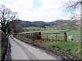
Ger Aberbechan Hall / Near Aberbechan Hall
Heol fach ger Aberbechan Hall. Mae llwybr cyhoeddus yn mynd drwy'r gât ar y dde.
A minor road near Aberbechan Hall (trans. confluence of the Bechan brook). A public footpath goes through the gate on the right.
Image: © Alan Richards
Taken: 21 Mar 2018
0.15 miles
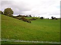
3
Pasture near Aberbechan Hall
There is a brook marked on the map following the line of the wooded gulley and running right down the slope but it doesn't appear to exist beyond the confines of the gulley.
Image: © Penny Mayes
Taken: 17 Oct 2007
0.19 miles

5
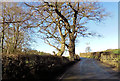
B4389 approaching overhead lines
Just east of road junction for Aberchain Bridge
Image: © John Firth
Taken: 19 Feb 2016
0.22 miles