IMAGES TAKEN NEAR TO
Upper Dolfor Road, NEWTOWN, SY16 3AB
Introduction
This page details the photographs taken nearby to Upper Dolfor Road, SY16 3AB by members of the Geograph project.
The Geograph project started in 2005 with the aim of publishing, organising and preserving representative images for every square kilometre of Great Britain, Ireland and the Isle of Man.

There are currently over 7.5m images from over14,400 individuals and you can help contribute to the project by visiting https://www.geograph.org.uk
Image Map
Images are licensed for reuse under creativecommons.org/licenses/by-sa/2.0
Notes
- Clicking on the map will re-center to the selected point.
- The higher the marker number, the further away the image location is from the centre of the postcode.
Image Listing (54 Images Found)
Images are licensed for reuse under creativecommons.org/licenses/by-sa/2.0
Image
Details
Distance
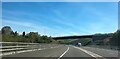
2

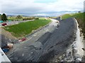
The bypass has been tidied up a bit
In preparation for this afternoon's public walk.
Seen from the Upper Dolfor Road bridge.
Image: © Penny Mayes
Taken: 21 Oct 2018
0.06 miles
3
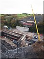
Constructing The Bridge Over The Middle Dolfor Road
Part of the construction of the Newtown bypass.
Image: © Chris Andrews
Taken: 14 Nov 2017
0.06 miles
4
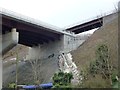
Newtown bypass bridge
Seen from Middle Dolfor Road. The bridge above it is on Upper Dolfor Road. The drainage channel seems very elaborate.
For reciprocal views see https://www.geograph.org.uk/photo/5962985 and https://www.geograph.org.uk/photo/5962990
For drone footage of the installation of the roadway beams on this bridge see https://www.youtube.com/watch?v=FTQFNdgILME
Image: © Penny Mayes
Taken: 1 Jan 2019
0.06 miles
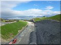
5
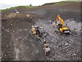
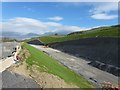
Parts of the embankment have already been turfed
The white line of concrete on the right is a drainage channel half way up the embankment. The small grey cylinders on the ground are rolls of mesh which will be pinned to the embankment to help stabilise it and prevent material falling onto the road surface.
Image: © Penny Mayes
Taken: 21 Oct 2018
0.06 miles
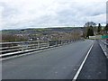
6
Overbridge over Newtown by-pass
The bridge carries Upper Dolfor Road. The underbridge in the foreground is the Middle Dolfor Road
Image: © John Firth
Taken: 11 May 2024
0.06 miles
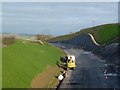
7
Parts of the embankment have already been turfed
Image: © Penny Mayes
Taken: 21 Oct 2018
0.07 miles
8
Newtown bypass
Crash barriers and road markings approach Upper Dolfor Road bridge.
Image: © Penny Mayes
Taken: 6 Jan 2019
0.07 miles
9
Looking down the Upper Dolfor Road bridge
With a view of the western end of the town beyond.
Image: © Penny Mayes
Taken: 1 Apr 2018
0.07 miles
10
Contoured embankment for the bypass
Seen from the Upper Dolfor Road bridge.
Image: © Penny Mayes
Taken: 21 Oct 2018
0.07 miles