IMAGES TAKEN NEAR TO
Brynglas Avenue, NEWTOWN, SY16 2QB
Introduction
This page details the photographs taken nearby to Brynglas Avenue, SY16 2QB by members of the Geograph project.
The Geograph project started in 2005 with the aim of publishing, organising and preserving representative images for every square kilometre of Great Britain, Ireland and the Isle of Man.

There are currently over 7.5m images from over14,400 individuals and you can help contribute to the project by visiting https://www.geograph.org.uk
Image Map
Images are licensed for reuse under creativecommons.org/licenses/by-sa/2.0
Notes
- Clicking on the map will re-center to the selected point.
- The higher the marker number, the further away the image location is from the centre of the postcode.
Image Listing (131 Images Found)
Images are licensed for reuse under creativecommons.org/licenses/by-sa/2.0
Image
Details
Distance
1
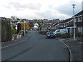
Brynglas Avenue
Looking down to the junction with Sycamore Drive.
Image: © Penny Mayes
Taken: 3 Nov 2011
0.06 miles
2
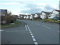
Sycamore Drive
Looking up from the junction with Brynglas Avenue.
Image: © Penny Mayes
Taken: 3 Nov 2011
0.06 miles
3
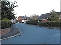
Beechwood Drive seen from Brynglas Avenue
Image: © Penny Mayes
Taken: 3 Nov 2011
0.06 miles
4
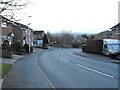
Sycamore Drive
Looking down to the junction with Sycamore Close. In spite of its name, Sycamore Close runs up to link with Old Barn Lane.
Image: © Penny Mayes
Taken: 3 Nov 2011
0.07 miles
5
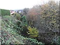
The cwm that runs parallel to Llanfair Road
After passing under Llanfair Road http://www.geograph.org.uk/photo/2707293 the brook turns south and runs down towards the Severn in a deep cwm or dingle.
Image: © Penny Mayes
Taken: 3 Nov 2011
0.07 miles
6
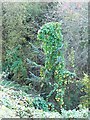
Young conifer smothered in bindweed
Growing in the cwm http://www.geograph.org.uk/photo/2707294.
Image: © Penny Mayes
Taken: 3 Nov 2011
0.08 miles
7
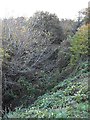
Deep cwm by Llanfair Road
After passing under Llanfair Road http://www.geograph.org.uk/photo/2707293 the brook, in this deep cwm, turns south and heads towards the Severn http://www.geograph.org.uk/photo/2707294. This view looks back towards the main road but the undergrowth completely conceals the bridge or culvert. The many white dots are convulvulus flowers.
Image: © Penny Mayes
Taken: 3 Nov 2011
0.09 miles
8
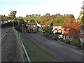
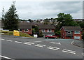
Cwm Llanfair
Cwm Llanfair is a small housing development beside the Llanfair Road, presumably named for the dingle http://www.geograph.org.uk/photo/2706729 which runs behind the houses between here and Sycamore Drive.
The building, near left, is part of the Montgomery County Infirmary.
Image: © Penny Mayes
Taken: 3 Nov 2011
0.10 miles
9
Cwm Llanfair, Newtown
Cwm Llanfair is a residential cul-de-sac on the east side of Llanfair Road.
Image: © Jaggery
Taken: 16 Jun 2013
0.10 miles
10
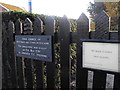
Sign on children's playground, Sycamore Drive
At the Sycamore Drive end of the footpath which runs down from Sycamore Drive, across the brook and into Cwm Llanfair.
Image: © Penny Mayes
Taken: 3 Nov 2011
0.10 miles