IMAGES TAKEN NEAR TO
Churchill Drive, NEWTOWN, SY16 2LE
Introduction
This page details the photographs taken nearby to Churchill Drive, SY16 2LE by members of the Geograph project.
The Geograph project started in 2005 with the aim of publishing, organising and preserving representative images for every square kilometre of Great Britain, Ireland and the Isle of Man.

There are currently over 7.5m images from over14,400 individuals and you can help contribute to the project by visiting https://www.geograph.org.uk
Image Map
Images are licensed for reuse under creativecommons.org/licenses/by-sa/2.0
Notes
- Clicking on the map will re-center to the selected point.
- The higher the marker number, the further away the image location is from the centre of the postcode.
Image Listing (325 Images Found)
Images are licensed for reuse under creativecommons.org/licenses/by-sa/2.0
Image
Details
Distance
2
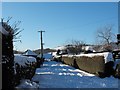
Snow on the old Barnfields estate
The bumpy pile of snow in the left foreground covers the rubbish and recycling bags put out for collection a couple of days previously. The food recycling truck made it up the steep and slippery slope to this unadopted road but it defeated the other collection vehicles.
Image: © Penny Mayes
Taken: 7 Jan 2010
0.04 miles
3
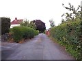
Unnamed private road in Barnfields
I'm told a name was once imposed upon this road but resident Welsh speakers objected to the connotations of the translation so the name does not appear on any maps and is never used. The dozen houses with an address on this road rely upon their postcode.
Image: © Penny Mayes
Taken: 14 Jul 2013
0.04 miles
4
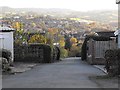
View from the top of Pine Tree Way, Barnfields
Pine Tree Way is one of two private roads in the old Barnfields estate. Most houses here were built in the 1950s.
The redundant church of St David Image http://www.geograph.org.uk/photo/1424901 with its tower is visible in the centre of the photo.
Beyond, above and to the right of the tower, is the Bethshan Care Home http://www.bethshan.org.uk/ on Heol Treowen. The housing estate across the hillside to the left is Treowen.
Image: © Penny Mayes
Taken: 3 Nov 2011
0.05 miles
5

Eastern leg of Pine Tree Way
On a sunny New Year's morning.
Although the two legs of this 1950s development are shown on maps as joined across the northern end, the link is a footpath, not a road. See Image Previously a private road, it was adopted by Powys County Council in recent years, hence the street light.
Image: © Penny Mayes
Taken: 1 Jan 2022
0.05 miles
6
Footpath joining two legs of Pine Tree Way
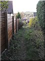
Although marked as a road on the map, the two legs of Pine Tree Way are linked at the northern end by this narrow, muddy path which continues west down to Old Barn Road.
Image: © Penny Mayes
Taken: 3 Nov 2011
0.05 miles
7

Scarlet Tiger Moth (Callimorpha dominula)
I don't think I've ever seen one of these before, very striking!
Wikipedia: http://en.wikipedia.org/wiki/Scarlet_tiger_moth
Another shot: http://www.geograph.org.uk/photo/3569102
Image: © Penny Mayes
Taken: 19 Jul 2013
0.05 miles
8

Scarlet Tiger Moth (Callimorpha dominula)
I don't think I've ever seen one of these before, very striking!
Wikipedia: http://en.wikipedia.org/wiki/Scarlet_tiger_moth
Another shot: http://www.geograph.org.uk/photo/3569101
Image: © Penny Mayes
Taken: 19 Jul 2013
0.05 miles
9

Mini power station on Barn Lane
On a sunny New Year's morning.
Image: © Penny Mayes
Taken: 1 Jan 2022
0.05 miles
10
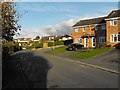
Old Barn Lane
A recent part of the Barnfields estate. The road to the right is Churchill Drive.
Image: © Penny Mayes
Taken: 3 Nov 2011
0.05 miles