IMAGES TAKEN NEAR TO
Cwrt Dolafon, Dolafon Road, NEWTOWN, SY16 2HU
Introduction
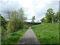
This page details the photographs taken nearby to Cwrt Dolafon, Dolafon Road, SY16 2HU by members of the Geograph project.
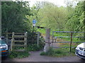
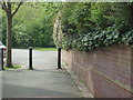
The Geograph project started in 2005 with the aim of publishing, organising and preserving representative images for every square kilometre of Great Britain, Ireland and the Isle of Man.

There are currently over 7.5m images from over14,400 individuals and you can help contribute to the project by visiting https://www.geograph.org.uk
Image Map
Images are licensed for reuse under creativecommons.org/licenses/by-sa/2.0
Notes
- Clicking on the map will re-center to the selected point.
- The higher the marker number, the further away the image location is from the centre of the postcode.
Image Listing (361 Images Found)
Images are licensed for reuse under creativecommons.org/licenses/by-sa/2.0
Image
Details
Distance
1
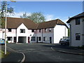
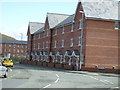
Dolafon, Canal Road
Development at Dolafon.
Image: © Henry Spooner
Taken: 23 Apr 2009
0.02 miles
2
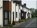
Dolafan Canal Road Newtown
Row of cottages in Dolafan Newtown
Image: © Henry Spooner
Taken: 13 May 2009
0.02 miles
3
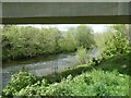
Llwybr glanafon y Drenewydd / Newtown riverside path
Llwybr ar lan Afon Hafren yn agosau at bont a garia heol dros yr afon.
A path on the banks of the Severn River approaching a road bridge.
Image: © Alan Richards
Taken: 21 Mar 2018
0.04 miles
4
Access to footpath from Dolafon Way
Entrance to riverside walk from Dolafon Terrace, Newtown, Powys
Image: © Henry Spooner
Taken: 17 May 2009
0.04 miles
5

Site of the Newtown Canal Basin
Although the whole place has been completely redeveloped since the infilling and closure of this end of the canal and is now a builders' merchant yard, the site here was once a busy canal basin. Historic Wales/Coflein records https://coflein.gov.uk/en/site/34591/ that it consisted of a large dock, surrounded by 7 'arms' of canal, each capable of holding 2 boats for loading or unloading, and served the tweed & flannel weaving businesses of the town, plus a significant number of nearby limekilns. All trace of those seems to have been removed as far as I could tell, apart from one house called The Limekilns.
Image: © Richard Law
Taken: 9 Jul 2022
0.04 miles
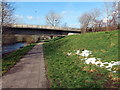
6
Severn Way (NCN81) and Cambrian Way bridge
Image: © David Smith
Taken: 5 May 2023
0.05 miles
7
Footpath from Cambrian Way to Dolafon
Dolafon Newtown
Image: © Henry Spooner
Taken: 13 May 2009
0.05 miles
8
Afon Way, Newtown, Powys
New houses at Afon Way, Canal Road,Newtown, Powys
Image: © Henry Spooner
Taken: 17 May 2009
0.05 miles
9
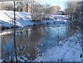
Ice building up on the Severn
With an overnight low of minus 12 degrees and snow on the ground for a couple of weeks, the river is low and the ice cover is spreading in spite of the speed of flow.
Image: © Penny Mayes
Taken: 25 Dec 2010
0.05 miles