IMAGES TAKEN NEAR TO
Chapel Street, NEWTOWN, SY16 2BP
Introduction
This page details the photographs taken nearby to Chapel Street, SY16 2BP by members of the Geograph project.
The Geograph project started in 2005 with the aim of publishing, organising and preserving representative images for every square kilometre of Great Britain, Ireland and the Isle of Man.

There are currently over 7.5m images from over14,400 individuals and you can help contribute to the project by visiting https://www.geograph.org.uk
Image Map
Images are licensed for reuse under creativecommons.org/licenses/by-sa/2.0
Notes
- Clicking on the map will re-center to the selected point.
- The higher the marker number, the further away the image location is from the centre of the postcode.
Image Listing (620 Images Found)
Images are licensed for reuse under creativecommons.org/licenses/by-sa/2.0
Image
Details
Distance
1
Commercial Street, Newtown, Powys
A view looking from the Crescent Island with the Grapes Hotel and the Textile Museum on the left hand side of the road.
Image: © Henry Spooner
Taken: 22 May 2009
0.00 miles
2
Old warehouse on Commercial Street - Wright's Radio factory
Built in the early 19th century, and at one time the premises of Wright's Radio factory. Grade II listed https://britishlistedbuildings.co.uk/300008048-premises-of-wrights-radio-and-roberts-quinn-newtown-and-llanllwchaiarn#.YsdPJXbMLIU in 1988.
Image: © Richard Law
Taken: 13 May 2022
0.01 miles
3
Former industrial building, Newtown
Newtown was a centre for the woollen and flannel industry in the 19th century.
Image: © Eirian Evans
Taken: 1 Jul 2009
0.01 miles
4
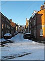
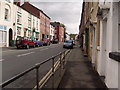
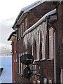
Chapel Street in the snow
Looking towards Commercial Street. Bryn Street continues in line beyond the junction.
Image: © Penny Mayes
Taken: 7 Jan 2010
0.01 miles
6
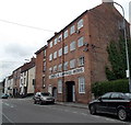
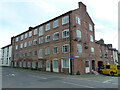
Former Commercial Carriage Works, Newtown
Viewed across Commercial Street looking towards the corner of Bryn Street.
The 4-storey building dates from the 1820s, originally a flannel mill, later used as carriage works.
The painted sign COMMERCIAL CARRIAGE WORKS on the wall was restored when the building was converted to flats c2000.
Image: © Jaggery
Taken: 16 Jun 2013
0.01 miles
7
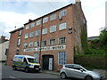
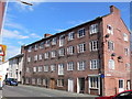
The (former) premises of Roberts and Quinn
An early 19th century flannel mill, with carriage works on the ground floor, which was Grade II listed https://britishlistedbuildings.co.uk/300008045-premises-of-roberts-and-quin-newtown-and-llanllwchaiarn#.YsdOvXbMLIU in 1988.
Image: © Richard Law
Taken: 13 May 2022
0.01 miles
8
House fitted into the street corner, Frankwell Street, Newtown
Image: © David Smith
Taken: 5 May 2023
0.01 miles
9
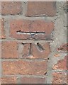
Ordnance Survey Cut Mark
This OS cut mark can be found on No1 Bay Villas. It marks a point 112.767m above mean sea level.
Image: © Adrian Dust
Taken: 29 Jan 2017
0.02 miles
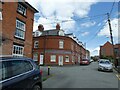
10
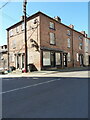
8 Chapel Street and 44 Commercial Street, Newtown
A mid 19th century Georgian house which is situated on the corner of Commercial St and Chapel St, and is actually the subject of 3 different Grade II listings under the headings of 8 Chapel St https://britishlistedbuildings.co.uk/300008053-chapel-street-newtown-and-llanllwchaiarn#.YxdMvnbMLIU on the left, Martin Harris (Butcher) shop https://britishlistedbuildings.co.uk/300008050-martin-harris-butcher-newtown-and-llanllwchaiarn#.YxdMxXbMLIV in the middle and 44 Commercial St https://britishlistedbuildings.co.uk/300008051-44-commercial-street-penygloddfa-powys-newtown-and-llanllwchaiarn#.YxdNWnbMLIU on the right. All the listings were given in May 1988.
Image: © Richard Law
Taken: 10 Jul 2022
0.02 miles