IMAGES TAKEN NEAR TO
Cambrian Gardens, NEWTOWN, SY16 2AW
Introduction
This page details the photographs taken nearby to Cambrian Gardens, SY16 2AW by members of the Geograph project.
The Geograph project started in 2005 with the aim of publishing, organising and preserving representative images for every square kilometre of Great Britain, Ireland and the Isle of Man.

There are currently over 7.5m images from over14,400 individuals and you can help contribute to the project by visiting https://www.geograph.org.uk
Image Map
Images are licensed for reuse under creativecommons.org/licenses/by-sa/2.0
Notes
- Clicking on the map will re-center to the selected point.
- The higher the marker number, the further away the image location is from the centre of the postcode.
Image Listing (725 Images Found)
Images are licensed for reuse under creativecommons.org/licenses/by-sa/2.0
Image
Details
Distance
1
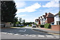
Cambrian Gardens taken from Cambrian Way, Newtown
Image: © Mick Malpass
Taken: 1 Sep 2012
0.03 miles
2
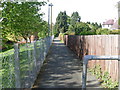
The "Wire Walk" Canal Road, Newtown
The "Wire Walk" connects Canal Road to the Edwards field housing estate and the pedestrian footbridge over the river Severn.
Image: © Henry Spooner
Taken: 4 May 2009
0.03 miles
3
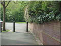
Footpath from Cambrian Way to Dolafon
Dolafon Newtown
Image: © Henry Spooner
Taken: 13 May 2009
0.04 miles
5
Cambrian House, Newtown
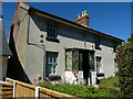
This late Georgian house is a bit of an odd survivor in this part of Newtown. Older maps from the turn of the 19th century show that it was apparently incorporated into the Lower Canal Road frontage of the large Cambrian Mill complex, a former woollen/flannel/tweed factory which occupied much of the site to the immediate southwest of here between the mid 1850s and 1912 when it was destroyed by fire. Perhaps it was a manager's house of some sort? Since the demolition of the rest of the mill buildings, it is now surrounded by newer developments in most directions, and was Grade II listed https://britishlistedbuildings.co.uk/300008127-cambrian-house-newtown-and-llanllwchaiarn#.Yxt09HbMLIV in 1988, presumably in an attempt to ensure its character was not entirely lost. It must be said at present, it does look a little sorry for itself, especially on the northern gable (at the far end of this photo) which can only really be described as 'ragged'.
Image: © Richard Law
Taken: 10 Jul 2022
0.05 miles
6
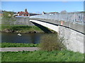
Footbridge over the River Severn, Newtown, Powys
Kings Bridge, Newtown, Powys
Image: © Henry Spooner
Taken: 17 May 2009
0.06 miles
7
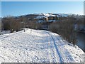
Snow on the banks of the Severn
The Royal Welsh warehouses visible against the hill in the background.
Taken from the Halfpenny Bridge.
Image: © Penny Mayes
Taken: 7 Jan 2010
0.06 miles
8
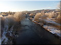
Severn Up
The River Severn flowing through Newtown.
Image: © J Scott
Taken: 6 Dec 2010
0.06 miles
9
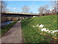
Llwybr glanafon y Drenewydd / Newtown riverside path
Llwybr ar lan Afon Hafren yn agosau at bont a garia heol dros yr afon.
A path on the banks of the Severn River approaching a road bridge.
Image: © Alan Richards
Taken: 21 Mar 2018
0.06 miles
10
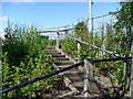
Access to the eastern end of the pedestrian bridge
Wooden steps to the footbridge into Newtown from Edwards field.
Image: © Henry Spooner
Taken: 22 Apr 2009
0.07 miles