1
View from the ridge road to Dolfor
The farm nearest the camera is Bryneira with bypass works just below it and Cefnaire a little further away on the right.
The collection of large brick buildings left of centre is Newtown High School with the new Welsh medium primary school Ysgol Dafydd Llwyd (white roofs, partially hidden by the hill) to its right.
The large grey roof to the right of that is the Lidl store on Llanidloes Road (A489) and beyond that, Latham Park football ground. The houses between them are part of the Trehafren estate which surrounds the hill to the left of the football ground.
The houses near the top of the photo are across the river on or off Milford Road (B4568).
Image: © Penny Mayes
Taken: 26 Mar 2017
0.01 miles
2
Water channel alongside Dolfor Road, Newtown
Much of this channel is underground, flowing through conduits. Here, alongside Dolfor Road, it is at the surface for about 70 metres.
Image: © Jaggery
Taken: 4 Aug 2013
0.02 miles
3
Newtown, Dolfor Road
New building under construction at the corner of Heol Treowen and Delfor Road. A sign on the hoarding states the Hope Church (
Image]) has relocated.
Image: © David Dixon
Taken: 15 Apr 2016
0.03 miles
4
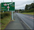
Warning sign for two overhead bridges, Newtown
The sign is alongside the A483 Dolfor Road. One http://www.geograph.org.uk/photo/3584168 of the bridges is in the background.
Image: © Jaggery
Taken: 4 Aug 2013
0.03 miles
5
Hope Church, Newtown
Situated on the corner of the A483 Dolfor Road and Heol Treowen, Hope Church is a contemporary, Bible-based community church with a Pentecostal heritage.
Newtown Pentecostal Church began at a crusade meeting in a tent in 1948. In the early 1950s the church became affiliated to the Assemblies of God. Meetings were held in various venues in the town until in 1977, a new church was built here. There have been various extensions and upgrades since then.
Image: © Jaggery
Taken: 4 Aug 2013
0.05 miles
6
Hope Day Nursery, Newtown
Viewed across the A483 Dolfor Road. Located at the northern end of Hope Church, http://www.geograph.org.uk/photo/3584098
Hope Day Nursery provides care for children from c3 months to 5 years old.
Image: © Jaggery
Taken: 4 Aug 2013
0.06 miles
7
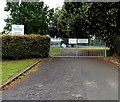
Visitors on school business only, Newtown High School
One notice on the gates at the Dolfor Road entrance to Newtown High School shows Visitors on school business only. The other notice shows No right of way through school grounds.
Image: © Jaggery
Taken: 4 Aug 2013
0.06 miles
8
A483
Image: © N Chadwick
Taken: 19 Feb 2015
0.08 miles
9
Newtown High School, Plantation Lane, Newtown, Powys
The main block of Newtown High School, Plantation Lane, Newtown, Powys.
Image: © Henry Spooner
Taken: 27 May 2009
0.09 miles
10
Stepped issue alongside Dolfor Road, Newtown
This water channel is shown on maps as an issue. The water descends steps to a conduit under Plantation Road and resurfaces about 100 metres behind the camera.
Image: © Jaggery
Taken: 4 Aug 2013
0.09 miles


