IMAGES TAKEN NEAR TO
Chirbury Road, MONTGOMERY, SY15 6QP
Introduction
This page details the photographs taken nearby to Chirbury Road, SY15 6QP by members of the Geograph project.
The Geograph project started in 2005 with the aim of publishing, organising and preserving representative images for every square kilometre of Great Britain, Ireland and the Isle of Man.

There are currently over 7.5m images from over14,400 individuals and you can help contribute to the project by visiting https://www.geograph.org.uk
Image Map
Images are licensed for reuse under creativecommons.org/licenses/by-sa/2.0
Notes
- Clicking on the map will re-center to the selected point.
- The higher the marker number, the further away the image location is from the centre of the postcode.
Image Listing (15 Images Found)
Images are licensed for reuse under creativecommons.org/licenses/by-sa/2.0
Image
Details
Distance
1
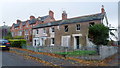
Old house in Montgomery
What an old gem, seemingly getting done up at last.
Image: © Jeremy Bolwell
Taken: 2 Nov 2014
0.04 miles
2

Old Milestone by the B4386, Chirbury Road, Montgomery parish
Stone post with iron plate by the B4386, in parish of Montgomery (Powys District), Chirbury Road, Hafod, on verge of main road near junction with New Road.
Inscription reads:-
21
MILES
FROM
SHREWSBURY
Grade II listed by Cadw.
Reference Number: 87248 https://cadwpublic-api.azurewebsites.net/reports/listedbuilding/FullReport?lang=&id=87248
Surveyed
Milestone Society National ID: MOT_MTSA00
Image: © Milestone Society
Taken: Unknown
0.05 miles
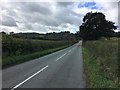
3

Chirbury Road, Montgomery
From the same spot as Image was taken, a view along the road leading out of Montgomery towards Chirbury. The silo tower in the distance is at Image
Image: © Derek Harper
Taken: 2 Jan 2009
0.09 miles
4

Farmland north-west of Montgomery
View of farmland and the B4386 to the north-west of Montgomery, viewed from Montgomery Castle. Offa's Dyke is visible, marked by a line of trees in the middle distance (just above to centre of the picture).
Image: © Philip Halling
Taken: 7 Jul 2010
0.11 miles
5
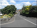
B4386 junction
Looking north-east along the road from its junction with Prince's Street.
Image: © Trevor Rickard
Taken: 6 Aug 2007
0.11 miles
7
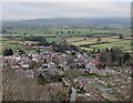
Montgomery viewed from the castle walls
Image: © Mat Fascione
Taken: 18 Dec 2021
0.12 miles
8
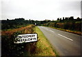
Cyrraedd Trefaldwyn / Arriving at Montgomery
Cyrraedd Trefaldwyn ar hyd yr A4386.
Arriving at Montgomery along the A4386.
Image: © Alan Richards
Taken: 25 Aug 1998
0.13 miles
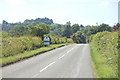
10
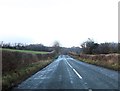
B4386 approaching Montgomery
The ruins of Montgomery Castle can be seen just to right of centre
Image: © John Firth
Taken: 7 Jan 2014
0.18 miles