IMAGES TAKEN NEAR TO
The Bank, MALPAS, SY14 8LD
Introduction
This page details the photographs taken nearby to The Bank, SY14 8LD by members of the Geograph project.
The Geograph project started in 2005 with the aim of publishing, organising and preserving representative images for every square kilometre of Great Britain, Ireland and the Isle of Man.

There are currently over 7.5m images from over14,400 individuals and you can help contribute to the project by visiting https://www.geograph.org.uk
Image Map (Loading...)


Getting Data...Please wait
Leaflet Map data © OpenStreetMap
Images are licensed for reuse under creativecommons.org/licenses/by-sa/2.0
Notes
- Clicking on the map will re-center to the selected point.
- The higher the marker number, the further away the image location is from the centre of the postcode.
Image Listing (15 Images Found)
Images are licensed for reuse under creativecommons.org/licenses/by-sa/2.0
Image
Details
Distance
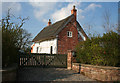
1
Thatched cottage in Edge village
Apparently named Brassey's Contract Cottage. Nice.
Image: © Jeremy Bolwell
Taken: 24 May 2012
0.02 miles
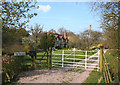
2
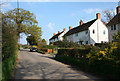
Semis on Brassey's Contract Road
Line of semi-detached houses, c1950s, on the south side of Brassey's Contract Road. The silage tower of Higher Hall is visible in the distance (see Image)
Image: © Espresso Addict
Taken: 8 Apr 2007
0.02 miles
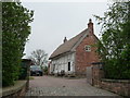
3
Brassey's Contract Cottage, Brassey's Contract Road
Grade-II-listed, mid-17th century, black-and-white thatched cottage on the north side of Brassey's Contract Road. The name suggests a link with railway builder, Thomas Brassey (1805-70). For more information, see http://www.imagesofengland.org.uk/search/details.aspx?id=55154
Image: © Espresso Addict
Taken: 8 Apr 2007
0.03 miles
4
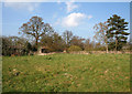
Pasture by Brassey's Contract Cottage
Small pasture field with mature deciduous trees in the hedgerow, adjacent to Brassey's Contract Cottage (right), to the north of Brassey's Contract Road. Typical of the land use in this square
Image: © Espresso Addict
Taken: 8 Apr 2007
0.06 miles
5
The Bryans, Brassey's Contract Road
Grade-II-listed, late 17th century, black-and-white cottage on the north side of Brassey's Contract Road. The cottage grounds back onto a narrow belt of woodland to the north of Brassey's Contract Road (left). For more information, see http://www.imagesofengland.org.uk/search/details.aspx?id=55152
Image: © Espresso Addict
Taken: 8 Apr 2007
0.08 miles
6
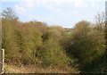
Cutting on disused railway, near Edge Green
Cutting on the disused railway from Whitchurch to Chester. View south from Brassey's Contract Road; the name of the road suggests a link with the railway builder, Thomas Brassey (1805-1870)
Image: © Espresso Addict
Taken: 8 Apr 2007
0.11 miles
7
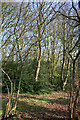
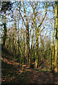
Woodland by Brassey's Contract Road
A narrow belt of mixed deciduous woodland to the north east of Brassey's Contract Road, near The Bryans
Image: © Espresso Addict
Taken: 8 Apr 2007
0.12 miles
8
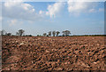
Ploughed field adjacent to the A41
A rare arable field in this area of predominantly pasture. The busy A41 runs beyond the hedge (right). View from Brassey's Contract Road
Image: © Espresso Addict
Taken: 8 Apr 2007
0.19 miles
9
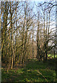
Woodland by embankment
Late afternoon sunlight on mixed deciduous woodland adjacent to the embankment on Hall Lane, just south of the railway bridge over the disused Whitchurch-Chester railway
Image: © Espresso Addict
Taken: 8 Apr 2007
0.21 miles
10
Line of disused railway, near Hall Lane bridge
View south down the disused Whitchurch to Chester railway line immediately south of the Hall Lane railway bridge. Although the former line has become overgrown with young trees, its direction can still be discerned
Image: © Espresso Addict
Taken: 8 Apr 2007
0.22 miles