IMAGES TAKEN NEAR TO
Oldcastle Lane, MALPAS, SY14 7AY
Introduction
This page details the photographs taken nearby to Oldcastle Lane, SY14 7AY by members of the Geograph project.
The Geograph project started in 2005 with the aim of publishing, organising and preserving representative images for every square kilometre of Great Britain, Ireland and the Isle of Man.

There are currently over 7.5m images from over14,400 individuals and you can help contribute to the project by visiting https://www.geograph.org.uk
Image Map (Loading...)


Getting Data...Please wait
Leaflet Map data © OpenStreetMap
Images are licensed for reuse under creativecommons.org/licenses/by-sa/2.0
Notes
- Clicking on the map will re-center to the selected point.
- The higher the marker number, the further away the image location is from the centre of the postcode.
Image Listing (13 Images Found)
Images are licensed for reuse under creativecommons.org/licenses/by-sa/2.0
Image
Details
Distance
1
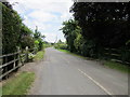
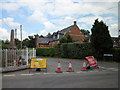
Oldcastle Lane, Upper Threapwood
Oldcastle Lane heading east from Chapel Lane.
Image: © Jeff Buck
Taken: 30 Jun 2014
0.02 miles
3
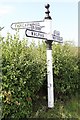
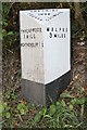
Old Direction Sign - Signpost by the B5069, Threapwood Parish
Pawn finial - 3 arms; Cheshire CCC octagonal by the B5069, in parish of Threapwood (Chester District), Chapel Lane junction, Threapwood North.
Surveyed
Milestone Society National ID: CH_SJ4446.
Image: © Milestone Society
Taken: Unknown
0.15 miles
4
Antique Milepost !
The Milepost on the B5069 has been in place almost 110 years and is still in good order. I wonder how many feet, hooves and tyres have passed by?
Image: © Paul Roberts
Taken: 30 Sep 2006
0.16 miles
5
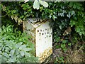
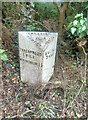
Old Milepost by the B5069, Wrexham Road, Threapwood
Cast iron post by the B5069, in parish of Threapwood (Vale Royal District), West of The Bank, in hedge, on South side of road. Cast iron CCC1898, erected by the County Council in the 19th century.
Inscription reads:-
: THREAPWOOD / 1 MILE / WORTHENBURY 1½ : : CHESHIRE / 1898 / COUNTY COUNCIL : : MALPAS / 3 MILES :
Maker:-
: W H SMITH & CO / MAKERS / WHITCHURCH :
Milestone Society National ID: CH_MPTP03
Image: © JV Nicholls & J Higgins
Taken: 20 Oct 2003
0.16 miles
6
Old Milepost by the B5069, Wrexham Road, Threapwood
Cast iron post by the B5069, in parish of Threapwood (Vale Royal District), West of The Bank, in hedge, on South side of road. Cast iron CCC1898, erected by the County Council in the 19th century. An earlier photograph can be found here: https://www.geograph.org.uk/photo/5622789
Inscription reads:-
: THREAPWOOD / 1 MILE / WORTHENBURY 1½ : : CHESHIRE / 1898 / COUNTY COUNCIL : : MALPAS / 3 MILES :
Maker:-
: W H SMITH & CO / MAKERS / WHITCHURCH :
Milestone Society National ID: CH_MPTP03
Image: © Nigel Upton
Taken: 7 Jul 2023
0.16 miles
8
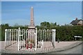
Threapwood War Memorial
Threapwood War Memorial at the junction of Sarn Road and Chapel Lane.
Wikipedia http://en.wikipedia.org/wiki/St_John%27s_Church,_Threapwood
Image: © Jeff Buck
Taken: 30 Jun 2014
0.17 miles
9
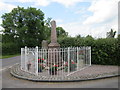
Road Junction at Threapwood
The junction of Chapel Lane and Sarn Road. The converted chapel can be seen behind the hedge with the war memorial on the left.
Image: © Jeff Buck
Taken: 30 Jun 2014
0.17 miles
10
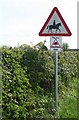
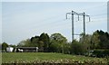
Mounted Vigilantes
Do the Neighbours watch from Horseback?
Image: © Geoff Evans
Taken: 19 Apr 2007
0.17 miles