IMAGES TAKEN NEAR TO
Farmlodge Lane, SHREWSBURY, SY1 3ST
Introduction
This page details the photographs taken nearby to Farmlodge Lane, SY1 3ST by members of the Geograph project.
The Geograph project started in 2005 with the aim of publishing, organising and preserving representative images for every square kilometre of Great Britain, Ireland and the Isle of Man.

There are currently over 7.5m images from over14,400 individuals and you can help contribute to the project by visiting https://www.geograph.org.uk
Image Map
Images are licensed for reuse under creativecommons.org/licenses/by-sa/2.0
Notes
- Clicking on the map will re-center to the selected point.
- The higher the marker number, the further away the image location is from the centre of the postcode.
Image Listing (23 Images Found)
Images are licensed for reuse under creativecommons.org/licenses/by-sa/2.0
Image
Details
Distance
1
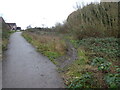
Path off the footpath
The walk we are following today follows the grassy path, or today muddy path.
Image: © Jeremy Bolwell
Taken: 3 Jan 2021
0.07 miles
2
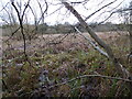
An old course of the River Severn on the outskirts of Shrewsbury
The Severn changed course at the end of the Last Glaciated period around 12,000 years ago, it is thought. This drastic alteration left its previous course as an empty river bed, or lowland, which remains to this day of course and is now an SSSI and wildlife haven on the edge of housing developments in the suburbs.
It looks a fascinating area, of marsh, bulrush beds, wetland grasses and scrub.
Image: © Jeremy Bolwell
Taken: 3 Jan 2021
0.11 miles
3
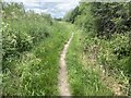
Footpath in the valley of Bagley Brook
Image: © John H Darch
Taken: 29 May 2022
0.15 miles
5
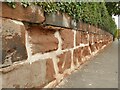
Eroded wall, Ellesmere Road
The local sandstone has eroded at varying rates.
Image: © Stephen Craven
Taken: 16 Oct 2022
0.18 miles
6
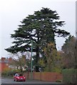
Cedar beside Ellesmere Road, Shrewsbury
Image: © David Smith
Taken: 28 Nov 2014
0.19 miles
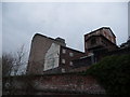
7
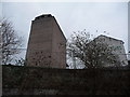
Part of Ditherington Flax Mill
Under redevelopment into a complex of shops, apartments and offices. Viewed from a track near the railway line.
Image: © Jeremy Bolwell
Taken: 31 Jan 2012
0.22 miles
8
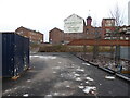
The rear view of Shrewsbury Flaxmill Maltings
Looking great.
Image: © Jeremy Bolwell
Taken: 3 Jan 2021
0.22 miles
9
Part of Ditherington Flax Mill
The buildings in the Flax Mill complex include associated or ancillary buildings such as the apprentice house, the dye house, the flax dressing building, the flax warehouse, the stables, workshops and offices. The mill and all its buildings are on the Buildings at Risk Register.
Today they are still very much a roost for colonies of pigeons.
Image: © Jeremy Bolwell
Taken: 31 Jan 2012
0.23 miles
10
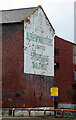
Shrewsbury Flax Mill Maltings - Cross Mill
The painted sign is on the gable end of Cross Mill. This was rebuilt in 1812 following a fire and is an iron-framed fireproof building used in the original flax mill and then adapted as part of the later maltings. it is Listed Grade I. Beyond it is the adapted former dyehouse that is Listed Grade II*.
Image: © Chris Allen
Taken: 3 Dec 2022
0.23 miles