IMAGES TAKEN NEAR TO
Stafford Drive, SHREWSBURY, SY1 3FE
Introduction
This page details the photographs taken nearby to Stafford Drive, SY1 3FE by members of the Geograph project.
The Geograph project started in 2005 with the aim of publishing, organising and preserving representative images for every square kilometre of Great Britain, Ireland and the Isle of Man.

There are currently over 7.5m images from over14,400 individuals and you can help contribute to the project by visiting https://www.geograph.org.uk
Image Map
Images are licensed for reuse under creativecommons.org/licenses/by-sa/2.0
Notes
- Clicking on the map will re-center to the selected point.
- The higher the marker number, the further away the image location is from the centre of the postcode.
Image Listing (18 Images Found)
Images are licensed for reuse under creativecommons.org/licenses/by-sa/2.0
Image
Details
Distance
1
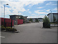
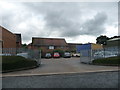
Stafford Drive, Battlefield Industrial Estate
From the DVLA car park. This is new development off the roundabout on Knight's Way opposite Hussey Road
Image: © John Firth
Taken: 25 Jul 2011
0.02 miles
2
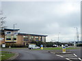
Island, Knights Way, Shrewsbury
At the junction with Stafford Drive and Hussey Road.
Image: © Roy Hughes
Taken: 18 Apr 2012
0.03 miles
3
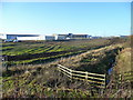
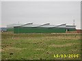
New business units
Encroachment of the land contained within the A5124 Shrewsbury northern bypass.
Image: © Jonathan Billinger
Taken: 8 Jan 2009
0.08 miles
4
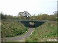
Subway under the Bypass
The bypass passes around the southern edge of the 1403 Shrewsbury Battlefield.
Image: © John M
Taken: 24 Apr 2010
0.12 miles
6
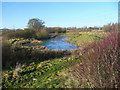
Wildlife pond
By the A5124 Shrewsbury northern bypass near the Battlefield business estate.
Image: © Jonathan Billinger
Taken: 8 Jan 2009
0.13 miles
7

Enterprise roundabout, Battlefield Link Road
Image: © Peter Whatley
Taken: 23 Mar 2012
0.16 miles

9
Old buildings off March Way, Battlefield Enterprise Park, Shrewsbury
The older timber framed buildings here must pre-date the business park that has grown up around this area.
Image: © Jeremy Bolwell
Taken: 4 Jul 2012
0.19 miles
10
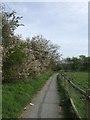
Footpath around the battlefield - Battle of Shrewsbury - 1403
The battle took place on 21st July 1403 between a rebel army raised by the Percy family of Northumberland and King Henry IV supported by his son Prince Hal. The rebels had grievances over money owing following their part in the overthrow of Richard II in 1399 and later assistance to the king. The battle is notable for the large scale deployment of English archers in both of the armies and set the pattern for the victory against the French at Agincourt. It is thought that the rebel army may have numbered 10,000 and the royal army 14,000.
Image: © John M
Taken: 24 Apr 2010
0.19 miles