IMAGES TAKEN NEAR TO
Mile Bank, WHITCHURCH, SY13 4JY
Introduction
This page details the photographs taken nearby to SY13 4JY by members of the Geograph project.
The Geograph project started in 2005 with the aim of publishing, organising and preserving representative images for every square kilometre of Great Britain, Ireland and the Isle of Man.

There are currently over 7.5m images from over14,400 individuals and you can help contribute to the project by visiting https://www.geograph.org.uk
Image Map
Images are licensed for reuse under creativecommons.org/licenses/by-sa/2.0
Notes
- Clicking on the map will re-center to the selected point.
- The higher the marker number, the further away the image location is from the centre of the postcode.
Image Listing (8 Images Found)
Images are licensed for reuse under creativecommons.org/licenses/by-sa/2.0
Image
Details
Distance
1
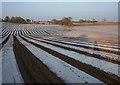
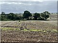
Polythene 'stripes' near Whitchurch
A large arable field north east of Whitchurch has been treated with polythene, presumably to protect recently planted seedlings; the resultant 'stripes' highlight the undulations in the ground. The foreground is in this gridsquare; the middle distance is in Image; the buildings (far distance) are Mile Bank Farm (far left) and a former factory (centre left and centre) in Image This view is north east; the view south east is shown in Image
Image: © Espresso Addict
Taken: 2 Apr 2009
0.06 miles
2
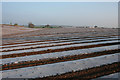
Polythene 'stripes' near Whitchurch
A large arable field north east of Whitchurch has been treated with polythene, presumably to protect recently planted seedlings; the resultant 'stripes' highlight the undulations in the ground. This view is broadly south east. The view north east is shown in Image
Image: © Espresso Addict
Taken: 2 Apr 2009
0.06 miles
3
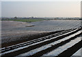
Polythene 'stripes' near Whitchurch
A large arable field north east of Whitchurch has been treated with polythene, presumably to protect recently planted seedlings; the resultant 'stripes' highlight the undulations in the ground. Whitchurch is in the distance (far right). View broadly south; the view south east is shown in Image
Image: © Espresso Addict
Taken: 2 Apr 2009
0.15 miles
4
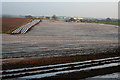
Polythene 'stripes' near Whitchurch
A large arable field north east of Whitchurch has been treated with polythene, presumably to protect recently planted seedlings; the resultant 'stripes' highlight the undulations in the ground. View broadly south east; the view south is shown in Image
Image: © Espresso Addict
Taken: 2 Apr 2009
0.15 miles
6
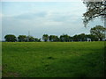
Farmland near Whitchurch
The Crewe to Shrewsbury rail line is not far beyond the hedge.
Image: © David Medcalf
Taken: 4 May 2006
0.17 miles
8
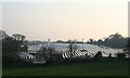
View towards Whitchurch near sunset
View towards Whitchurch from the partly demolished factory just to the north of the gridsquare boundary. The polythene 'stripes' catch the remains of the day's sun. The tower is St Alkmund's Church
Image: © Espresso Addict
Taken: 2 Apr 2009
0.24 miles