IMAGES TAKEN NEAR TO
Norbury, WHITCHURCH, SY13 4HR
Introduction
This page details the photographs taken nearby to SY13 4HR by members of the Geograph project.
The Geograph project started in 2005 with the aim of publishing, organising and preserving representative images for every square kilometre of Great Britain, Ireland and the Isle of Man.

There are currently over 7.5m images from over14,400 individuals and you can help contribute to the project by visiting https://www.geograph.org.uk
Image Map (Loading...)


Getting Data...Please wait
Leaflet Map data © OpenStreetMap
Images are licensed for reuse under creativecommons.org/licenses/by-sa/2.0
Notes
- Clicking on the map will re-center to the selected point.
- The higher the marker number, the further away the image location is from the centre of the postcode.
Image Listing (9 Images Found)
Images are licensed for reuse under creativecommons.org/licenses/by-sa/2.0
Image
Details
Distance
1
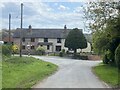
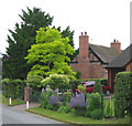
Cottages by road junction
In the centre of Norbury.
Image: © John H Darch
Taken: 25 Apr 2022
0.01 miles
2
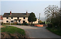
Terraced cottages, Norbury
A terrace of cottages at the junction of Norbury Town Lane, School Lane and the lane to Gauntons Bank on the eastern edge of the hamlet of Norbury. Norbury occupies a minor elevation and the descent to the valley in which the Llangollen branch of the Shropshire Union Canal runs can be seen (right) along School Lane, with the rise at Wirswall in the distance. The old-fashioned black-and-white signposts (left) are common in this area
Image: © Espresso Addict
Taken: 27 Mar 2007
0.01 miles
3
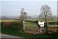
Carthorse at Norbury
Placid carthorse in a field beside the lane to Gauntons Bank on the eastern edge of the hamlet of Norbury. Undulating pasture running down to the Llangollen branch of the Shropshire Union Canal and then up towards to Wirswall forms the backdrop
Image: © Espresso Addict
Taken: 27 Mar 2007
0.04 miles
4
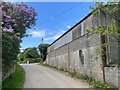
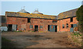
Farm building at Higher Hall Farm, Norbury
Image: © John H Darch
Taken: 25 Apr 2022
0.08 miles
5
Farm buildings, Higher Hall Farm, Norbury
Typical red-brick slate-roofed outbuildings, with diamond pattern ventilation holes, at Higher Hall Farm in the hamlet of Norbury
Image: © Espresso Addict
Taken: 27 Mar 2007
0.09 miles
6
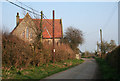
Former chapel, Norbury
Marked as a chapel on the 1940s map, this stone-faced building on Norbury Town Lane in the hamlet of Norbury is now residential. The plethora of unsightly telegraph poles of assorted vintages is common in this area
Image: © Espresso Addict
Taken: 27 Mar 2007
0.17 miles
7
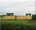
Mown field, Gauntons Bank
Near the junction of the Gauntons Bank and Norbury roads, and typical of the agricultural use of this area
Image: © Espresso Addict
Taken: 20 Jun 2006
0.21 miles
8
Brook Farm, Gauntons Bank
Grade-II-listed, timber-framed red-brick farmhouse dating from the late 16th or early 17th century, located by the junction of the Gauntons Bank and Norbury roads. For more information: http://www.imagesofengland.org.uk/search/details.aspx?id=422362
Image: © Espresso Addict
Taken: 20 Jun 2006
0.22 miles
9
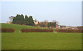
The Mount, Norbury
The Mount is a substantial dairy farm which dominates the low elevation (100m) on which the hamlet of Norbury is located. The stone-trimmed, grey-rendered farmhouse faces away from the lane; it is atypical of the simpler red-brick farmhouses generally found locally. The barns (right) are currently being converted for residential use. The sloping pasture in the foreground is typical of the land use in this gridsquare
Image: © Espresso Addict
Taken: 27 Mar 2007
0.25 miles