IMAGES TAKEN NEAR TO
Ightfield, WHITCHURCH, SY13 4BL
Introduction
This page details the photographs taken nearby to SY13 4BL by members of the Geograph project.
The Geograph project started in 2005 with the aim of publishing, organising and preserving representative images for every square kilometre of Great Britain, Ireland and the Isle of Man.

There are currently over 7.5m images from over14,400 individuals and you can help contribute to the project by visiting https://www.geograph.org.uk
Image Map
Images are licensed for reuse under creativecommons.org/licenses/by-sa/2.0
Notes
- Clicking on the map will re-center to the selected point.
- The higher the marker number, the further away the image location is from the centre of the postcode.
Image Listing (7 Images Found)
Images are licensed for reuse under creativecommons.org/licenses/by-sa/2.0
Image
Details
Distance
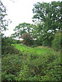
3
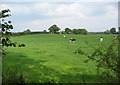
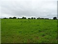
Cattle pasture by Oakhill Farm
Undulating cattle pasture is typical of this area. Oakhill Farm, one of several small farms in the area, is just out of frame on the right. View from Lodmore Lane
Image: © Espresso Addict
Taken: 12 Sep 2006
0.15 miles
4
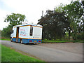
The mobile library comes to Lodmore Lane
The Shropshire mobile library van stops opposite The Beeches on Lodmore Lane. Shropshire County Council runs seven vans which operate on a fortnightly basis to bring library services to rural communities. For more information: http://www.shropshire.gov.uk/library.nsf
Image: © Espresso Addict
Taken: 12 Sep 2006
0.15 miles
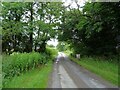
6
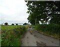
Boundary between Cheshire and Shropshire
The county boundary here runs along a small brook, a tributary of Dodcott Brook (hidden in trees on right). View from Lodmore Lane
Image: © Espresso Addict
Taken: 12 Sep 2006
0.22 miles
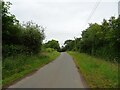
7
Lodmore Lane
Bridge over the Dodcott Brook marks the county boundary between Shropshire and Cheshire.
Image: © JThomas
Taken: 3 Jul 2024
0.25 miles