IMAGES TAKEN NEAR TO
Park Terrace, Whitchurch Road, WHITCHURCH, SY13 2DE
Introduction
This page details the photographs taken nearby to Park Terrace, Whitchurch Road, SY13 2DE by members of the Geograph project.
The Geograph project started in 2005 with the aim of publishing, organising and preserving representative images for every square kilometre of Great Britain, Ireland and the Isle of Man.

There are currently over 7.5m images from over14,400 individuals and you can help contribute to the project by visiting https://www.geograph.org.uk
Image Map
Images are licensed for reuse under creativecommons.org/licenses/by-sa/2.0
Notes
- Clicking on the map will re-center to the selected point.
- The higher the marker number, the further away the image location is from the centre of the postcode.
Image Listing (3 Images Found)
Images are licensed for reuse under creativecommons.org/licenses/by-sa/2.0
Image
Details
Distance
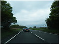
2
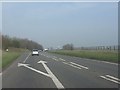
A49 at the northern junction for Prees
Image: © Peter Whatley
Taken: 23 Mar 2012
0.18 miles
3
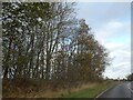
Woodland by A49 north of Prees
The road which became the A49 ran through Prees. When Prees was bypassed, the old road (named Whitchurch Road) was realigned to have a right-angle junction with the A49 just south of the wood. The trees in this small woodland mark the old route
Image: © David Smith
Taken: 4 Dec 2021
0.22 miles