IMAGES TAKEN NEAR TO
De Warenne Close, WHITCHURCH, SY13 1TS
Introduction
This page details the photographs taken nearby to De Warenne Close, SY13 1TS by members of the Geograph project.
The Geograph project started in 2005 with the aim of publishing, organising and preserving representative images for every square kilometre of Great Britain, Ireland and the Isle of Man.

There are currently over 7.5m images from over14,400 individuals and you can help contribute to the project by visiting https://www.geograph.org.uk
Image Map
Images are licensed for reuse under creativecommons.org/licenses/by-sa/2.0
Notes
- Clicking on the map will re-center to the selected point.
- The higher the marker number, the further away the image location is from the centre of the postcode.
Image Listing (97 Images Found)
Images are licensed for reuse under creativecommons.org/licenses/by-sa/2.0
Image
Details
Distance
1
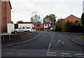
Edgeley Gardens, Whitchurch
Cul-de-sac viewed from Edgeley Road.
Image: © Jaggery
Taken: 22 Oct 2015
0.06 miles
2
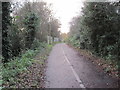
Whitchurch to Oswestry railway trackbed
View south west towards Fenn's bank and Oswestry. The line closed in 1965 and is now a path and cycleway.
Image: © Nigel Thompson
Taken: 24 Nov 2015
0.08 miles
3
Rydal Avenue, Whitchurch
From Edgeley Road.
Image: © Jaggery
Taken: 22 Oct 2015
0.08 miles
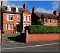
4
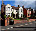
Three Edgeley Road houses, Whitchurch
Two semi-detached houses on the left, detached house on the right.
Image: © Jaggery
Taken: 22 Oct 2015
0.08 miles
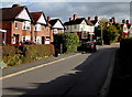
5
Winton, Edgeley Road, Whitchurch
Winton is inscribed on the right side of the house, below the pair of first floor windows.
Image: © Jaggery
Taken: 22 Oct 2015
0.08 miles
6
Corner of Edgeley Road and Edgeley Gardens, Whitchurch
Edgeley Road houses viewed past the corner of Edgeley Gardens, a cul-de-sac. http://www.geograph.org.uk/photo/4763798
Image: © Jaggery
Taken: 22 Oct 2015
0.09 miles
7
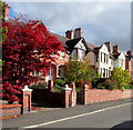
Red leaves, Edgeley Road, Whitchurch
Near the corner of Rydal Avenue.
Image: © Jaggery
Taken: 22 Oct 2015
0.09 miles
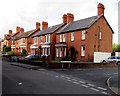
8
Edgeley Road towards Rydal Avenue, Whitchurch
The black car is parked near the corner of Rydal Avenue.
Image: © Jaggery
Taken: 22 Oct 2015
0.10 miles
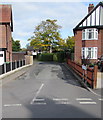
9
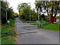
Hatton Way towards Whitchurch railway station
Heading away from Edgeley Road, the combined footpath & cycleway follows the route of a dismantled railway.
Image: © Jaggery
Taken: 22 Oct 2015
0.10 miles
10
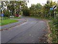
End of the 30 zone, Edgeley Road, Whitchurch
The 30mph speed limit increases to the National Speed Limit. A No Through Road sign is on the left.
Old maps show that Edgeley Road used to be a through road. Now it is severed by the A525, 550 metres ahead. Near the A525, metal barriers across Edgeley Road block the passage of motor vehicles, but not walkers and cyclists.
Image: © Jaggery
Taken: 22 Oct 2015
0.10 miles