IMAGES TAKEN NEAR TO
Mount Crescent, WHITCHURCH, SY13 1GW
Introduction
This page details the photographs taken nearby to Mount Crescent, SY13 1GW by members of the Geograph project.
The Geograph project started in 2005 with the aim of publishing, organising and preserving representative images for every square kilometre of Great Britain, Ireland and the Isle of Man.

There are currently over 7.5m images from over14,400 individuals and you can help contribute to the project by visiting https://www.geograph.org.uk
Image Map
Images are licensed for reuse under creativecommons.org/licenses/by-sa/2.0
Notes
- Clicking on the map will re-center to the selected point.
- The higher the marker number, the further away the image location is from the centre of the postcode.
Image Listing (96 Images Found)
Images are licensed for reuse under creativecommons.org/licenses/by-sa/2.0
Image
Details
Distance
1
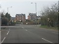
Western end of London Road, Whitchurch
Image: © Peter Whatley
Taken: 23 Mar 2012
0.04 miles
3
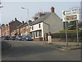
Country Tour anyone?
Sign at the eastern end of Chester Road, Whitchurch. Do people still "go out for a drive" in 2012 as we used to do in the 1960s when fuel was 7s 6d per gallon (about 8p per litre)?
Image: © Peter Whatley
Taken: 23 Mar 2012
0.04 miles
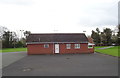
5
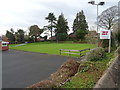
Bowling green, Chester Road Bowling Club, Whitchurch
Image: © JThomas
Taken: 14 Mar 2019
0.06 miles
6
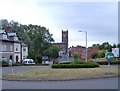
Whitchurch - "The Mount" roundabout
Whitchurch. View towards the town from the roundabout at the junction of the former A49 (now B5476) (Tarporley Road) with the B5395 (Chester Road and London Road). Whitchurch parish church (St. Alkmond's) is in the background, 270m away at the head of Bargates.
Image: © Mike Harris
Taken: 13 Aug 2006
0.07 miles
7
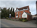
The Hollies, Whitchurch
An Office complex based in a Victorian built House, which was previously a hotel.
Image: © JThomas
Taken: 14 Mar 2019
0.07 miles
8

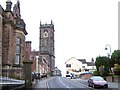
Whitchurch, Bargates
Looking towards St Alkmund's Church.
Image: © David Dixon
Taken: 11 Apr 2016
0.09 miles
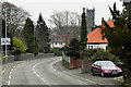
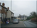
10
Whitchurch - Bargates
Whitchurch. Bargates is the name of the street leading up to the church from the north. Parish church of St. Alkmond (100m) ahead where Bargates becomes the High Street. On the left, the old grammar school (see Image). On the right the Greyhound pub.
Image: © Mike Harris
Taken: 13 Aug 2006
0.12 miles