IMAGES TAKEN NEAR TO
New Park Close, SHREWSBURY, SY1 2SQ
Introduction
This page details the photographs taken nearby to New Park Close, SY1 2SQ by members of the Geograph project.
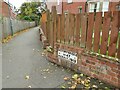
The Geograph project started in 2005 with the aim of publishing, organising and preserving representative images for every square kilometre of Great Britain, Ireland and the Isle of Man.

There are currently over 7.5m images from over14,400 individuals and you can help contribute to the project by visiting https://www.geograph.org.uk
Image Map
Images are licensed for reuse under creativecommons.org/licenses/by-sa/2.0
Notes
- Clicking on the map will re-center to the selected point.
- The higher the marker number, the further away the image location is from the centre of the postcode.
Image Listing (133 Images Found)
Images are licensed for reuse under creativecommons.org/licenses/by-sa/2.0
Image
Details
Distance
1
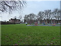
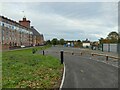
Recreation ground in the Spring Gardens area of Shrewsbury
Actually being used too.
Image: © Jeremy Bolwell
Taken: 3 Jan 2021
0.07 miles
2
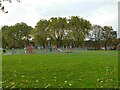
Playground off St Michael's Street
Seen from the nearby greenway.
Image: © Stephen Craven
Taken: 16 Oct 2022
0.07 miles
3
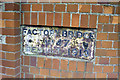
Plate on Shrewsbury Canal bridge 47, 1990
Factory Bridge, rebuilt 1913 has only the parapet on the south side of the A5191 surviving, but traces of the other may survive as brickwork reduced to near pavement level. The canal traffic dwindled to nothing in the 1930s and was formally abandoned in 1944.
Image: © Robin Webster
Taken: 27 Sep 1990
0.07 miles
4
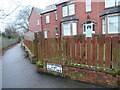
Old canal related signage beside the main road
The footpath here follows the line of the old Shrewsbury Canal I think. This sign is one of the few remaining elements of that era.
Image: © Jeremy Bolwell
Taken: 3 Jan 2021
0.07 miles
5
Factory Bridge plaque
The plaque would have been on the bridge that took St Michael's Street over the Shrewsbury Canal and took its name from the nearby flaxmill. It is in near enough its original location as this cycleway follows the line of the former canal.
Image: © Stephen Craven
Taken: 16 Oct 2022
0.07 miles
6
Zebra crossing on St Michael's Street
Image: © Stephen Craven
Taken: 16 Oct 2022
0.07 miles
7
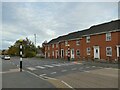
'The Maltings' Hair and Beauty Salon
This has the appearance of a converted public house. The name refers to the former brewery maltings opposite in the Ditherington Flax Mill complex.
The houses beyond date from the early 1800s and were built to house workers in the mill. Apprentice and clerks houses were provided within the complex.
The trapezoidal plan shape of the building reflects the course of the Shrewsbury Canal which crossed the road diagonally at this point.
Image: © John M
Taken: 19 Sep 2009
0.08 miles
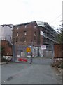
8
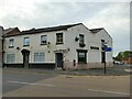
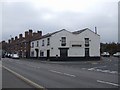
Building on the corner of St Michael's Street and Crewe Street
The building, originally a pub as shown on the 1902 map, has an unusual double-pitched roof. It is currently for sale but was most recently used as a hair salon. There is a postbox in the wall. See Image for further comment.
Image: © Stephen Craven
Taken: 16 Oct 2022
0.08 miles
9
Cycleway past Ditherington Flaxmill and Maltings
The cycleway roughly follows the line of the former Shrewsbury Canal. See Image for more details of the old mill buildings.
Image: © Stephen Craven
Taken: 16 Oct 2022
0.09 miles
10
Ditherington Flax Mill
Grade 2 listed extennsion to the main mill building. The Shrewsbury Canal ran approimately 30feet from the face of the building. The photograph is taken on the approximate line of canal.
Image: © John M
Taken: 19 Sep 2009
0.09 miles