IMAGES TAKEN NEAR TO
Benbow Quay, SHREWSBURY, SY1 2DH
Introduction
This page details the photographs taken nearby to Benbow Quay, SY1 2DH by members of the Geograph project.
The Geograph project started in 2005 with the aim of publishing, organising and preserving representative images for every square kilometre of Great Britain, Ireland and the Isle of Man.

There are currently over 7.5m images from over14,400 individuals and you can help contribute to the project by visiting https://www.geograph.org.uk
Image Map
Images are licensed for reuse under creativecommons.org/licenses/by-sa/2.0
Notes
- Clicking on the map will re-center to the selected point.
- The higher the marker number, the further away the image location is from the centre of the postcode.
Image Listing (534 Images Found)
Images are licensed for reuse under creativecommons.org/licenses/by-sa/2.0
Image
Details
Distance
1
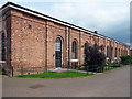
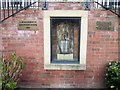
Former engine house, Benbow Place, Shrewsbury
Built for Shrewsbury and Chester Railway by Thomas Brassey in 1849, a "rare early survival of the sort of maintenance provision that was usually rapidly replaced or modified out of all recognition". It has a handsome sequence of arched windows divided by piers.
Converted to houses - the developers have managed to stretch to three storeys.
Image: © Stephen Richards
Taken: 16 May 2014
0.02 miles
3
Muddy track towards Greenfields Gardens, Shrewsbury
Muddy on December 1st 2015, the track has been created by hundreds or
perhaps thousands of walkers taking the same shortcut across grass.
Image: © Jaggery
Taken: 1 Dec 2015
0.04 miles
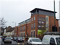
4
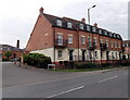
Benbow Quay, Shrewsbury
Part of a recent housing development viewed across the A528 Coton Hill.
Image: © Jaggery
Taken: 31 May 2014
0.05 miles
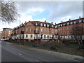
6
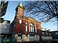
Old converted Congregational church in Shrewsbury, now apartments
The old building has been respected and converted into what I am sure are amazing apartments.
Image: © Jeremy Bolwell
Taken: 3 Jan 2021
0.06 miles
7
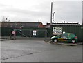
Lock Stock Self Storage entrance gates and van, Shrewsbury
Located in Crewe Bank Yard, accessed from Castle Foregate.
Image: © Jaggery
Taken: 1 Dec 2015
0.06 miles
8
Traffic queueing in Chester Street, Shrewsbury
The Anchorage, overlooking the road and the river, is a recent development, "nestling on the banks of the Severn"
Image: © David Smith
Taken: 28 Nov 2014
0.06 miles
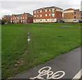
9
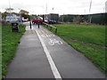
Southern end of a cycle path from Greenfields Gardens, Shrewsbury
Greenfields Gardens is an area of modern housing http://www.geograph.org.uk/photo/4755181
which is accessed by motor vehicles from the A528 Ellesmere Road.
Image: © Jaggery
Taken: 1 Dec 2015
0.06 miles
10
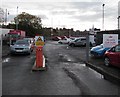
You are now under surveillance, Shrewsbury
The message is under a depiction of a CCTV camera on the yellow sign at the entrance to a Royal Mail private car park set back 65 metres from the west side of the A5191 Castle Foregate. No unauthorised vehicles allowed.
Image: © Jaggery
Taken: 1 Dec 2015
0.06 miles