1
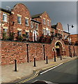
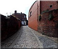
Belmont Bank, Shrewsbury
Image: © Dave Croker
Taken: 30 Jul 2009
0.02 miles
2
Parapet topping Shrewsbury's town wall
A large section of the 13th century, medieval town wall on the south side of the former boundary of Shrewsbury remains in place, and is built of large sandstone blocks with this road 'Town Walls' being built pretty much on top of it. The wall itself isn't easily visible from the road or the path, but can be seen from the allotments, gardens and tennis courts on the far side of the road (if you can gain access to them...). The parapet wall seen here is a later addition, and in many places is the result of 18th century and later repair work. The whole was Grade II* listed https://britishlistedbuildings.co.uk/101254934-town-walls-shrewsbury#.YrQQZ3bMI2w & https://historicengland.org.uk/listing/the-list/list-entry/1254934 in 1995. The section east of Belmont Crescent is also designated as a Scheduled (Ancient) Monument.
Image: © Richard Law
Taken: 22 May 2022
0.02 miles
3
Bishopstone Mansions, Shrewsbury
Part of the street named Town Walls.
Image: © Jaggery
Taken: 15 Oct 2013
0.02 miles
4
Ordnance Survey Cut Mark
This OS cut mark can be found on the Town Walls. It marks a point 59.515m above mean sea level.
Image: © Adrian Dust
Taken: 3 Jul 2023
0.02 miles
5
Vegetable garden
Below the Town Walls. We could not work out how this garden was accessed. A bowls pavilion backs on to it. The use of the building is made clear not only by the bowling green beyond, but by the weather vane too.
Image: © David Lally
Taken: 10 Sep 2010
0.02 miles
6
Up Belmont Bank, Shrewsbury
The lane ascends towards Sycamore House at 9 Belmont Bank.
Image: © Jaggery
Taken: 31 May 2014
0.02 miles
7
Town Walls and the BT Exchange
Looking along Town Walls with the huge BT telephone exchange building in the background.
Image: © John S Turner
Taken: 7 May 2009
0.03 miles
8
OS benchmark -Shrewsbury, Town Walls near telephone exchange
An OS cutmark on the Town Walls near the BT/GPO telephone exchange building; originally levelled at 59.515m above Ordnance Datum Newlyn.
Image: © Richard Law
Taken: 7 Jan 2017
0.03 miles
9
Bowling greens below Town Walls
Looking down on the bowling greens below Town Walls. The small figure playing bowls in the centre of the photo is in fact a weathervane on the roof of the pavilion. Below the figure are the centenary dates 1896-1996, but I have been unable to establish the name of the club or sports ground.
Image: © John S Turner
Taken: 7 May 2009
0.03 miles
10
7 Belmont, Shrewsbury
Dated c1700. Quite charming but very plain and its facade disrupted by an off-centre entrance. The gatepiers are almost grander than the house. Grade II* listed.
Image: © Stephen Richards
Taken: 11 May 2014
0.03 miles


