IMAGES TAKEN NEAR TO
Town Walls, SHREWSBURY, SY1 1TN
Introduction
This page details the photographs taken nearby to Town Walls, SY1 1TN by members of the Geograph project.
The Geograph project started in 2005 with the aim of publishing, organising and preserving representative images for every square kilometre of Great Britain, Ireland and the Isle of Man.

There are currently over 7.5m images from over14,400 individuals and you can help contribute to the project by visiting https://www.geograph.org.uk
Image Map
Images are licensed for reuse under creativecommons.org/licenses/by-sa/2.0
Notes
- Clicking on the map will re-center to the selected point.
- The higher the marker number, the further away the image location is from the centre of the postcode.
Image Listing (1389 Images Found)
Images are licensed for reuse under creativecommons.org/licenses/by-sa/2.0
Image
Details
Distance
1
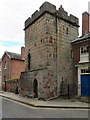
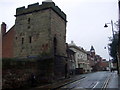
Town Walls Tower
The Town Walls Tower is the last remaining medieval watchtower surviving on what were once the medieval fortified walls of Shrewsbury. The tower, which dates from the 14th century, is now in the care of the National Trust.
Image: © David Dixon
Taken: 25 Jul 2010
0.00 miles
2
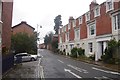
Town Walls, Shrewsbury
Road following the course of the town wall, parallel with the looping Severn.
Image: © Richard Webb
Taken: 2 Aug 2016
0.00 miles
3
Town Walls Tower
The Town Walls Tower is the last remaining medieval watchtower surviving on what were once the medieval fortified walls of Shrewsbury. The tower, which dates from the 14th century, is now in the care of the National Trust.
Image: © David Dixon
Taken: 25 Jul 2010
0.01 miles
4
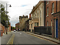
27 & 28 Town Walls, Shrewsbury
Built around 1800 as a pair of houses, but more recently in commercial/office use, and the white notice on the railings suggests they are owned or used by the nearby Shrewsbury High School at present. They were collectively Grade II listed https://britishlistedbuildings.co.uk/101255054-27-and-28-town-walls-shrewsbury#.Yrv3DHbMKUl & https://historicengland.org.uk/listing/the-list/list-entry/1255054 in 1953.
Image: © Richard Law
Taken: 22 May 2022
0.01 miles
5
Watch tower on Town Walls
This is the last remaining mediaeval watch tower set along the town walls to guard against attacks by the Welsh from across the river which it overlooks. It was the Normans who provided the first defensive wall for the town in the early 12th, the walls were strengthened subsequently and the towers probably erected in the early C14th.
The Welsh name for Shrewsbury is Amwythig meaning "fortified place".
The tower is in the ownership of the National Trust and privately rented.
Image: © Natasha Ceridwen de Chroustchoff
Taken: 4 Feb 2010
0.01 miles
6
Town Walls, Shrewsbury
Road (A458) running along the site of what were once the medieval fortified walls of Shrewsbury. Image], in the background, is the last surviving watchtower.
Image: © David Dixon
Taken: 25 Jul 2010
0.01 miles
7
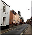
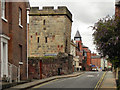
Narrow Town Walls, Shrewsbury
Looking along the street named Town Walls from near the corner of Swan Hill.
A one-way traffic system (towards the camera) is in force along this narrow road.
Double yellow lines on both sides of the road make parking illegal here.
Image: © Jaggery
Taken: 15 Oct 2013
0.01 miles
8
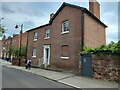
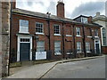
26 Town Walls, Shrewsbury
The house was built around 1800, but the roughly-coursed sandstone walls to either side are considerably older, being part of the 13th century town defensive wall. No 26, with the iron railings leading up to its doorway, was Grade II listed https://britishlistedbuildings.co.uk/101254931-number-26-and-attached-walls-and-railings-shrewsbury#.Yrv5BXbMKUk & https://historicengland.org.uk/listing/the-list/list-entry/1254931 in 1972, whilst the older wall is also a Scheduled Monument.
Image: © Richard Law
Taken: 22 May 2022
0.01 miles
9
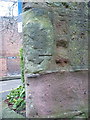
OS benchmark - Shrewsbury, 26 Town Walls
An OS cutmark on the corner of the wall at 26 Town Walls; originally levelled at 60.411m above Ordnance Datum Newlyn.
Image: © Richard Law
Taken: 7 Jan 2017
0.02 miles
10
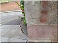
Ordnance Survey Cut Mark
This damaged OS cut mark can be found on the Town Walls. It marks a point 60.411m above mean sea level.
Image: © Adrian Dust
Taken: 3 Jul 2023
0.02 miles