IMAGES TAKEN NEAR TO
Mardol Head, SHREWSBURY, SY1 1HE
Introduction
This page details the photographs taken nearby to Mardol Head, SY1 1HE by members of the Geograph project.
The Geograph project started in 2005 with the aim of publishing, organising and preserving representative images for every square kilometre of Great Britain, Ireland and the Isle of Man.

There are currently over 7.5m images from over14,400 individuals and you can help contribute to the project by visiting https://www.geograph.org.uk
Image Map
Images are licensed for reuse under creativecommons.org/licenses/by-sa/2.0
Notes
- Clicking on the map will re-center to the selected point.
- The higher the marker number, the further away the image location is from the centre of the postcode.
Image Listing (1818 Images Found)
Images are licensed for reuse under creativecommons.org/licenses/by-sa/2.0
Image
Details
Distance
1
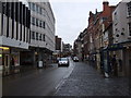
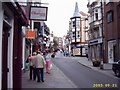
Looking up Shoplatch
Towards Mardol Head. The Market Hall is across the street on the left.
The name Shoplatch is thought to derive from a family called Schutte who owned property in the area since in 1295 the street was referred to as 'Scheteplache'.
Image: © Natasha Ceridwen de Chroustchoff
Taken: 3 Feb 2010
0.00 miles
2
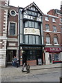
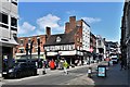
The Hole in the Wall public house
Grade II listed https://www.britishlistedbuildings.co.uk/101254849-the-hole-in-the-wall-public-house-shrewsbury#.WsXGMvnwaM8 & https://historicengland.org.uk/listing/the-list/list-entry/1254849 in 1972, the Hole in the Wall is recorded by Historic England as being purpose-built as a public house in the 1860s.
Image: © Richard Law
Taken: 24 Mar 2018
0.00 miles
3

Rear part of the National Westminster Bank, Shrewsbury
Tucked away in Gullett Passage behind the main street frontage Image lies this single-storey extension to the banking hall. It forms part of the 1993 Grade II listing https://britishlistedbuildings.co.uk/101254625-national-westminster-bank-shrewsbury#.YeMCpv7P3IU & https://historicengland.org.uk/listing/the-list/list-entry/1254625.
Image: © Richard Law
Taken: 9 Jan 2022
0.00 miles
5
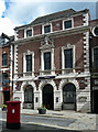
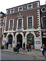
8 Mardol Head, Shrewsbury
Lavish early C20th Baroque, built in 1926 for the National Provincial Bank by its own architects, F.C.R. Palmer & W.F.C. Holden (three initials were obligatory). The carving was by G. & A. Brown Ltd. Grade II listed.
Now a branch of NPB's successor, Natwest Bank.
Image: © Stephen Richards
Taken: 12 May 2014
0.01 miles
6
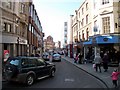
Mardol Head
Photo taken from Mardol Head Shrewsbury looking up Pride Hill
Image: © Mr M Evison
Taken: 21 Sep 2003
0.01 miles
7

Rear entrance and part of the building - The Hole in the Wall pub
Seen here from the rear in Gullett Passage, this is the rear entranceway to Image, a Grade II listed https://britishlistedbuildings.co.uk/101254849-the-hole-in-the-wall-public-house-shrewsbury#.YeLz7P7P3IU & https://historicengland.org.uk/listing/the-list/list-entry/1254849 pub which was built in the 1860s.
Image: © Richard Law
Taken: 9 Jan 2022
0.01 miles
9
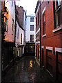
Shrewsbury: Gullet Passage
One of Shrewsbury's many narrow passageways, or "shuts" in the local usage.
Image: © Christopher Hilton
Taken: 21 Nov 2012
0.01 miles
10
NatWest Bank premises, Shoplatch
Built in 1926 to a Neo-Renaissance style, the bank building was Grade II listed https://www.britishlistedbuildings.co.uk/101254625-national-westminster-bank-shrewsbury#.WsXMXvnwaM8 in 1993.
Image: © Richard Law
Taken: 24 Mar 2018
0.01 miles